DLA 2021 Poster
The three winning DLA 2021 posters from three continents!
We are very happy to announce the results of 2021 DLA poster compettion.
From the 43 submitted posters, a jury of 15 reviewers selected two posters, each having earned the highest rating, as the winning posters.
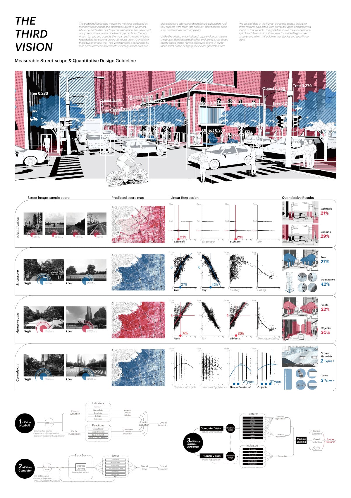
This year’s DLA poster entry titled “The third vision: measurable street-scape & a quantitative design guideline” by Yuehui Du of Columbia University, Graduate School of Architecture, Planning and Preservation GSAPP and Xun Liu, University of Virginia, USA was one of the two best entries.

Tied for first place was the poster titled:
“A new approach to IoT: evaluating the users’ mental health and well-being in urban landscapes; digital analysis of post-Covid experiences” by
Zahra Shirzadian, Roya Naamipouran and Farshad Akar, Shiraz University, Iran,
both received the final average score of 5 after evaluation by eight reviewers.

Each team will be awarded prize money of 350 Euros.
The poster submission entitled “Detection of Invasive Neophytes using Novel Artificial Intelligence Algorithms” by
Nicolas Tobler, Raphael Unterer, Cengiz Akandil and Guido Schuster from OST – Eastern Switzerland University of Applied Sciences at Rapperswil, Switzerland, with a rating of 4,75 by eight reviewers, receives the third prize and 250 Euros.
Congratulations to the three winning teams from three different continents!
The fifteen reviewers were drawn from the participants of the DLA 2021 conference and gave their expert evaluations on poster entries from 16 different countries.

We want to thank the 15 reviewers who each took the time to look through all the poster submissions displayed at http://2021.dla-conference.com/poster-2021/
The non-cash prizes for 4th to-10th place go to
“Residential Development in Southern Sachsen-Anhalt” by Drini Berati, Anhalt University, Germany (score 4.71)
“Measuring Landscape Connectivity in Northwest Chatham County, Georgia; USA” by Jiyue Zhao, University of Georgia, United States (score 4.67)
“Wolfsburg Resilient City as a Climate Garden, City Space History + Digital Landscape Architecture” by Esha Kundu, Anhalt University, Germany (score 4.56)
“Energy Landscape of the Oss Region” by Kitti Biró-Varga, Wageningen University & Research, Netherlands (score 4.50)
“What if We Map the Forest Loss Data of 113 Terrestrial Protected Landscape in the Philippines? Prioritization for Restoration, Conservation, and Preservation through Hansen Global Forest Loss Dataset” by Charl Justine Darapisa, Seoul National University, South Korea (score 4.44)
“Landscape Plan Pavlov – Using GIS to Protect Cultural Landscape” by Kristýna Kohoutková, Mendel University, Czech Republic in Brno (score 4.33)
“CITY YARD” by Bilge Kobak, Gülay Didir, Selin Kaya, Sinem Atak, Irmak Çatalcalı,Seçil Yılmaz Çetin, Design team from Istanbul Technical University and Yıldız Technical University, Turkey and Politecnico di Milano. Italia (score 4.29),
and with the same average score;
“The Socio-Cultural Benefits of Retrofitting Stormwater Channels to Green Channels: Feasibility Study and Design Proposal from Jeddah City, Saudi Arabia” by Abdulmueen Bogis, Virginia Tech, United States
We are very pleased about the wide range of landscape architecture students’ contributions from around the world on different approaches of Resilient Landscape Architecture. Thank you to all contributors!
And thank you reviewers:
Andrea Haase, Sara Tanzila Manami, Henry Wagler, Sigrid Hehl-Lange, Eckart Lange, Nicole Uhrig, Catharina Bankert-Hahn, Max Marohn, Verena Vogler, Hans-Georg Schwarz-v. Raumer, Stephen Ervin, Pia Fricker, John Danahy, Tess Canfield and James Palmer.
We also would like to thank VECTORWORKS as this year’s main sponsor of the poster competition.
————————
Erich Buhmann, DLA-JODLA, t-online.de
All DLA 2021 Poster
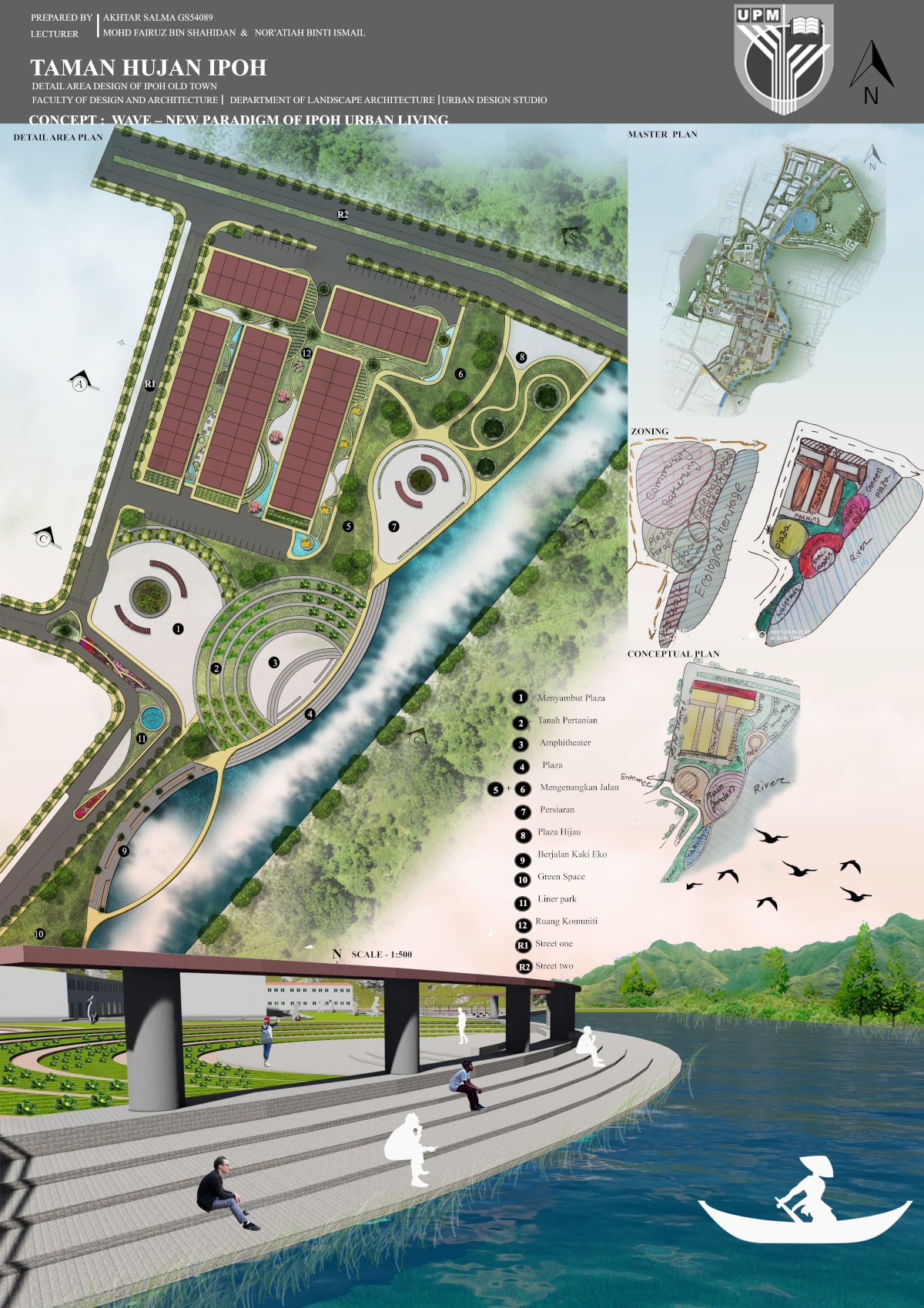
Taman Hujan Ipoh
Author: Salma Akhtar
Universiti Putra Malaysia, Bangladesh
Residential Development in Southern Sachsen-Anhalt: Special Recognition
Author: Drini Berati
Hochschule Anhalt_Master of Landscape Architecture, Germany
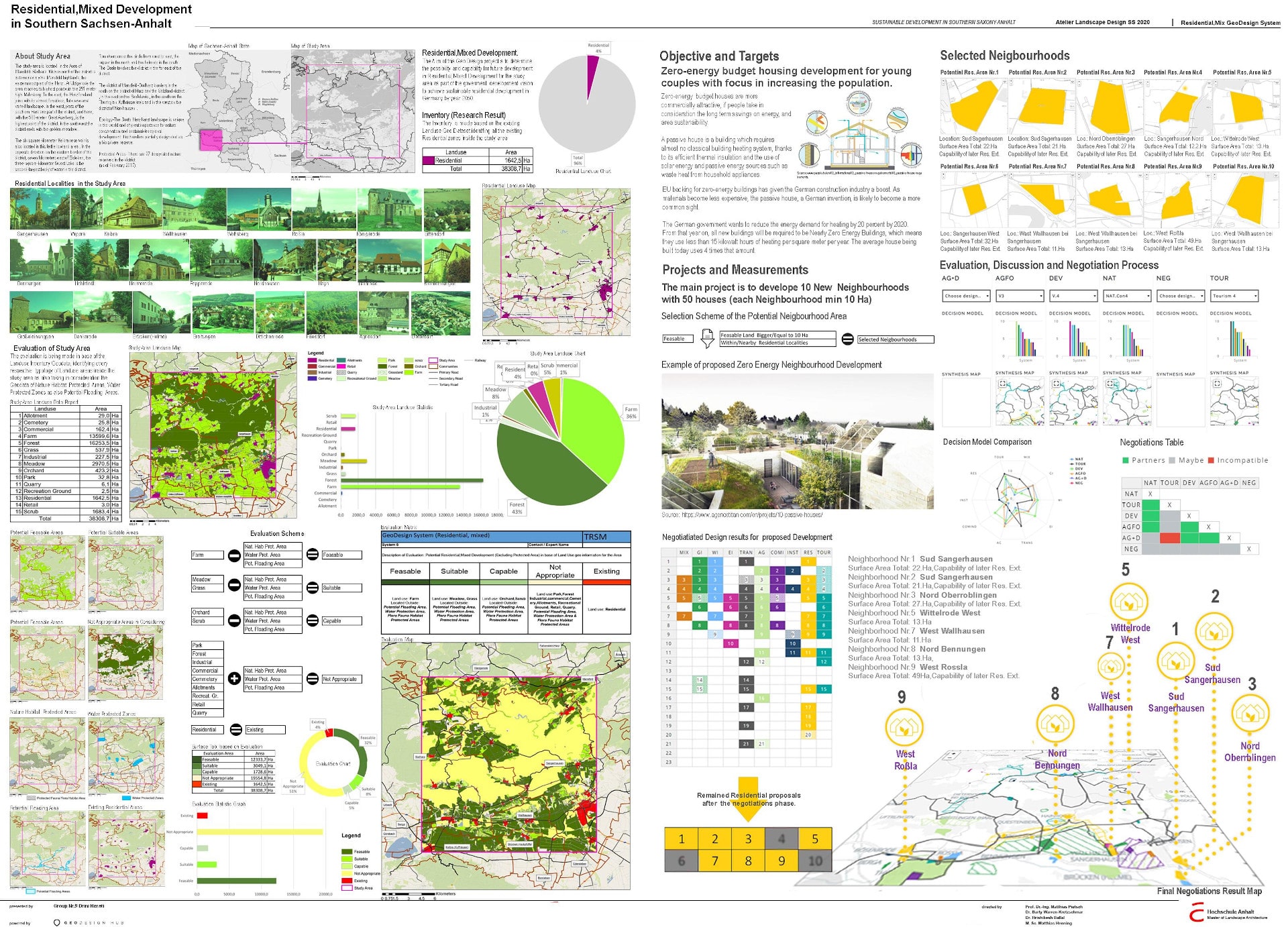
The analysis is based on the assessment from the spatial data of the land use inventory taking into account the following data: Protected areas for natural habitats, water protection areas, spatial data information on potential floodplains.
Target group: young couples & families.
Proposal: 10 new net-zero residential areas (at least 10 ha / neighborhood) with passive houses on low-cost.
Sustainable goal: The German government wanted to reduce the energy demand for heating by 20% by 2020.
This means that from now on all residential investments must be near zero net energy houses, by consuming less than 15 kw / h of heating per sq.m. As materials become less expensive, the passive house invention becomes more a common sight, concept in which is based the proposal.
International Garden Culture: A Contemporary Approach to Islamic Garden Design High score by visitors’ vote
Author: Abu Sayeed Mohammed Ziad
Hochschule Anhalt, Germany
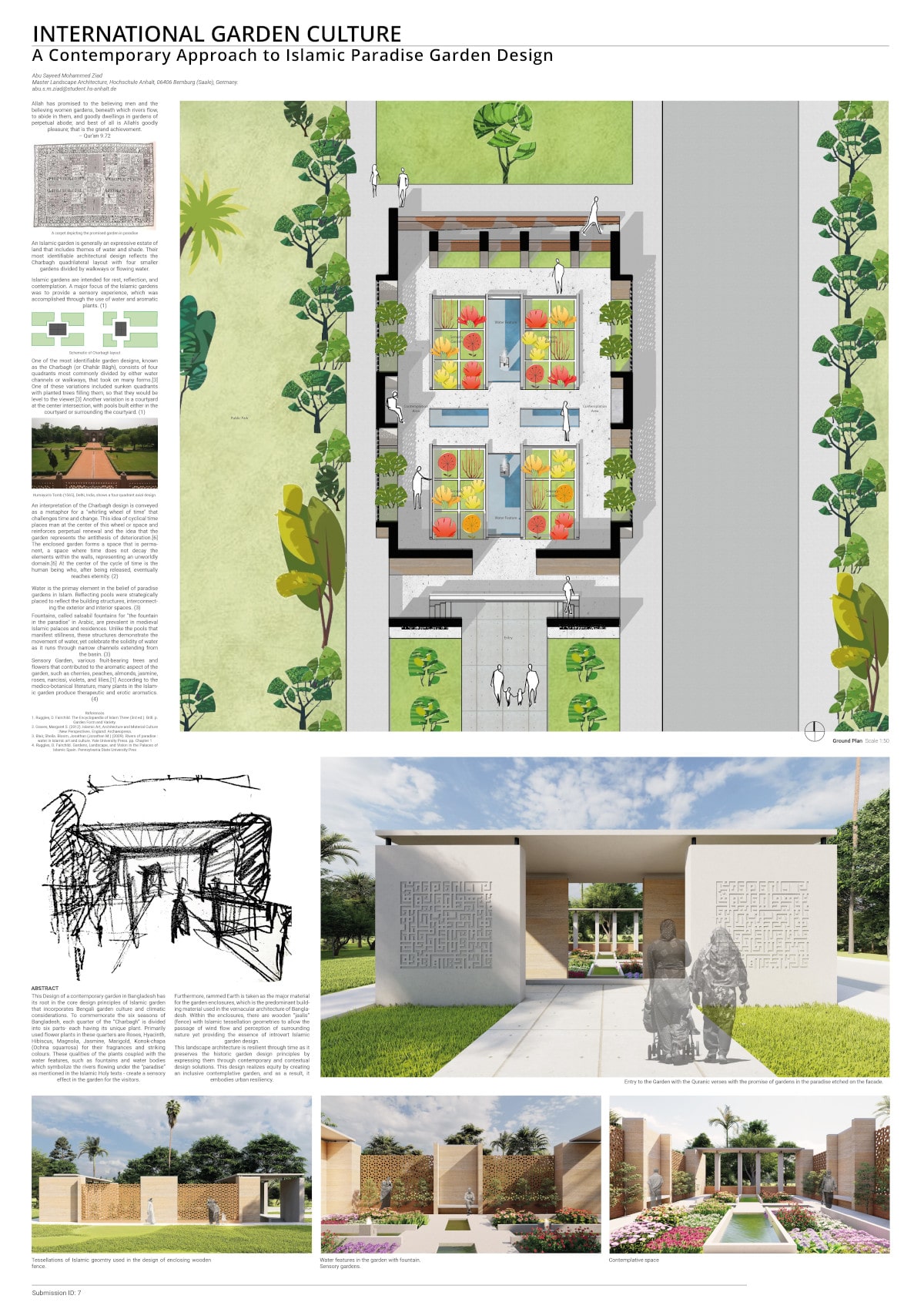
This landscape architecture is resilient through time as it preserves the historic garden design principles by expressing them through contemporary and contextual design solutions. This design realizes equity by creating an inclusive contemplative garden, and as a result, it embodies urban resiliency.
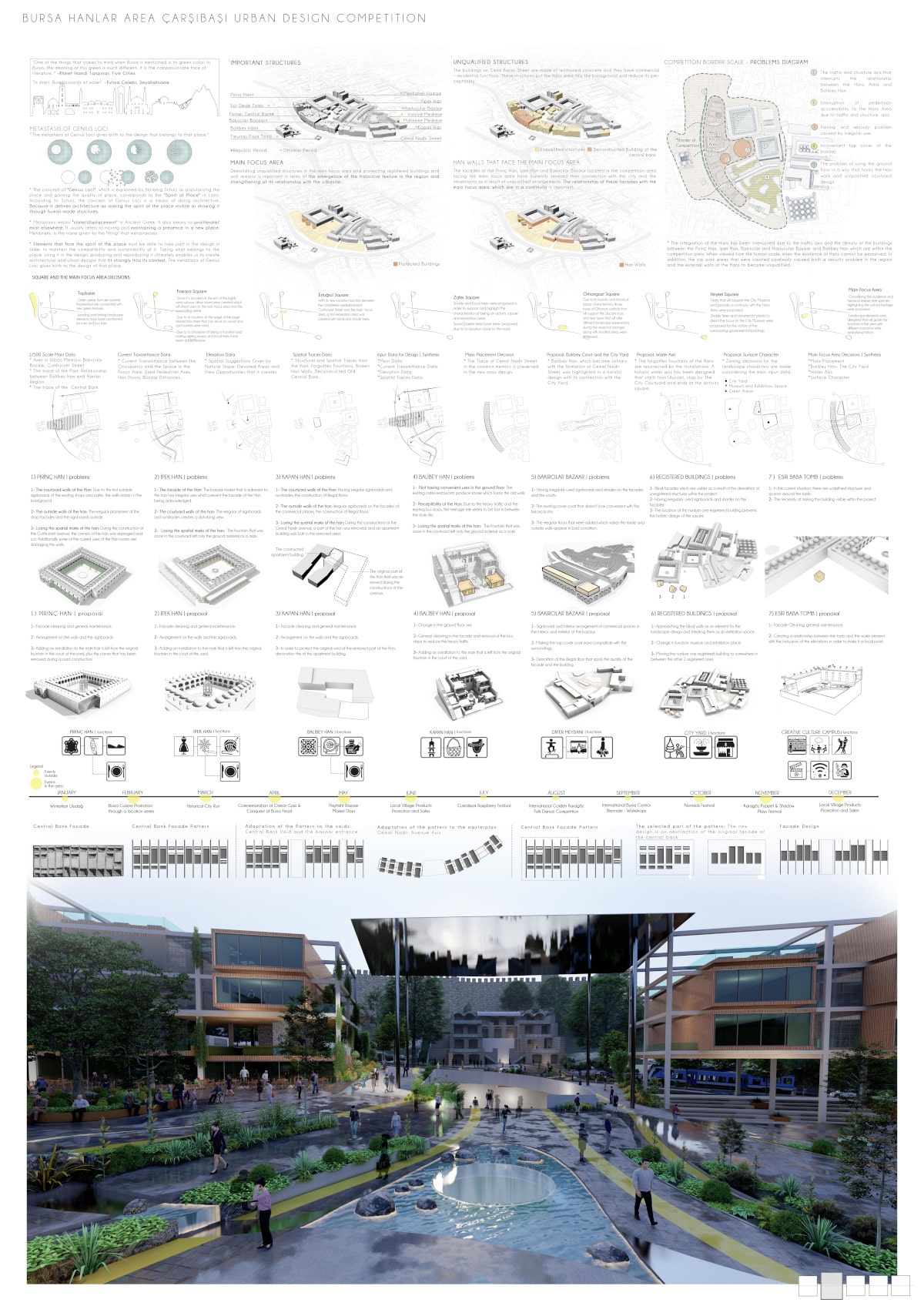
CITY YARD Special Recognition
Authors:
- Bilge Kobak (Italy)
- Gülay Didir (Turkey)
- Selin Kaya (Turkey)
- Sinem Atak (Turkey)
- Irmak Çatalcalı (Turkey)
- Seçil Yılmaz Çetin – Uludağ University, Turkey
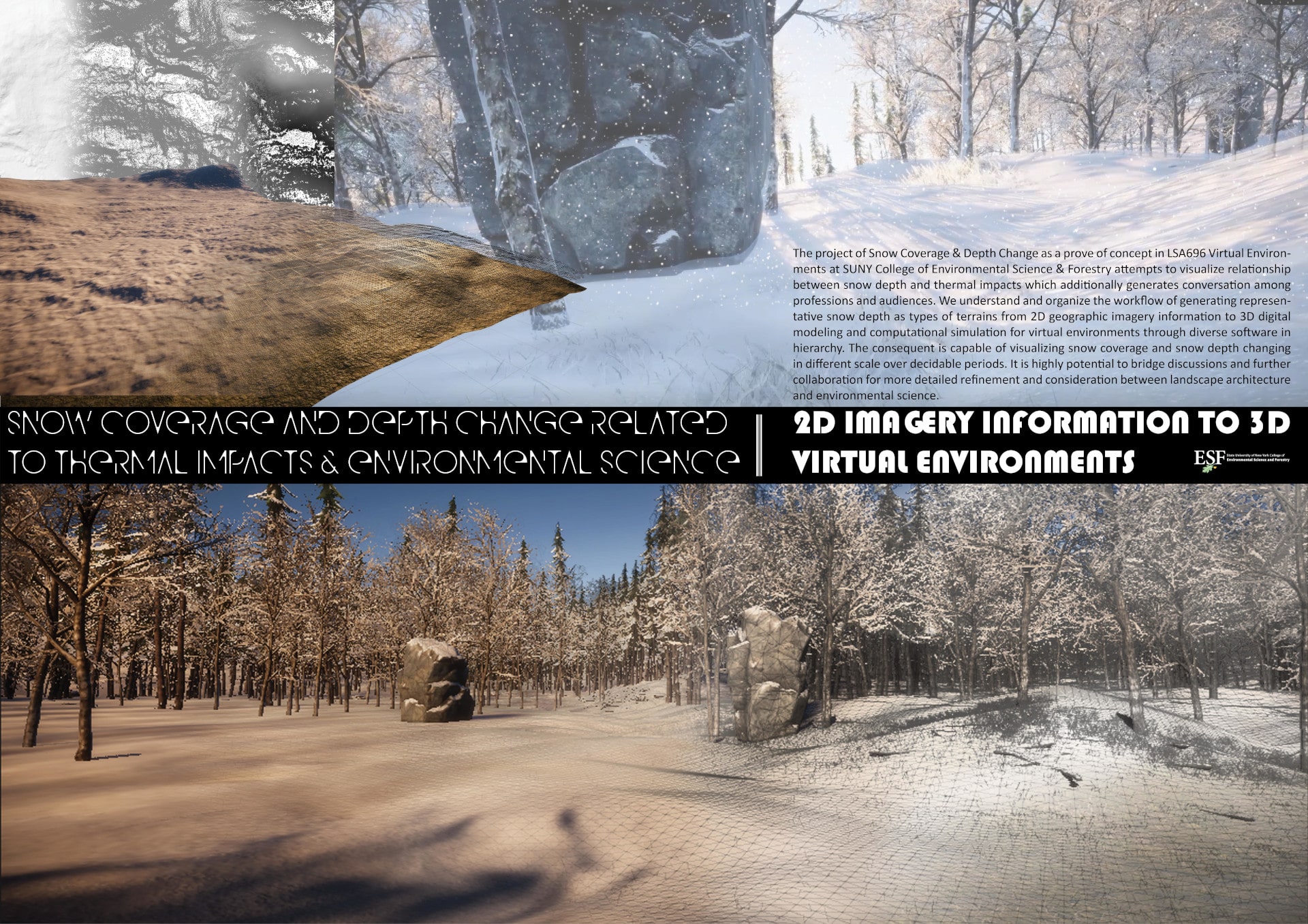
Snow Coverage and Depth Change related to Thermal Impacts and Environmental Science
Author: Chien-Yu Lin
SUNY College of Environmental Science and Forestry, United States
EXPLORING CHINA’S SILICON VALLEY BEFORE IT IS BUILT
Authors:
- Xi Lu, University of Sheffield, China
- Adam Tomkins, University of Sheffield, United Kingdom
- Sigrid Hehl-Lange, University of Sheffield, United Kingdom
- Eckart Lange, University of Sheffield, United Kingdom
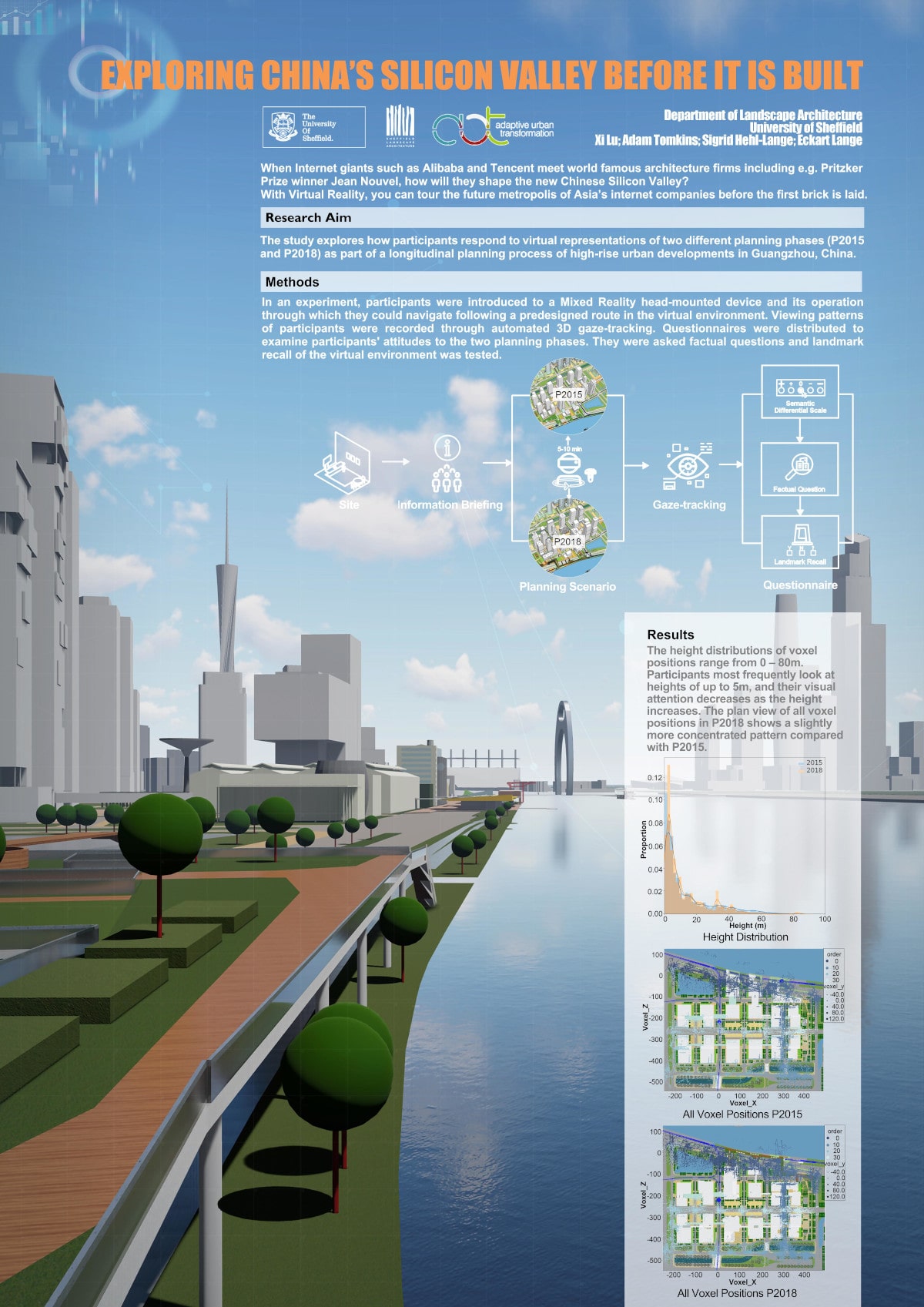
When Internet giants such as Alibaba and Tencent meet world-famous architecture firms including e.g. Pritzker Prize winner Jean Nouvel, how will they shape the new Chinese Silicon Valley? With Virtual Reality, you can tour the future metropolis of Asia’s internet companies before the first brick is laid.
Research Aim:
The study explores how participants respond to virtual representations of two different planning phases (P2015 and P2018) as part of a longitudinal planning process of high-rise urban developments in Guangzhou, China.
Methods:
In an experiment, participants were introduced to a Mixed Reality head-mounted device and its operation through which they could navigate following a predesigned route in the virtual environment. Viewing patterns of participants were recorded through automated 3D gaze-tracking. Questionnaires were distributed to examine participants’ attitudes to the two planning phases. They were asked factual questions and landmark recall of the virtual environment was tested.
Results:
The height distributions of voxel positions range from 0 – 80m. Participants most frequently look at heights of up to 5m, and their visual attention decreases as the height increases. The plan view of all voxel positions in P2018 shows a slightly more concentrated pattern compared with P2015.
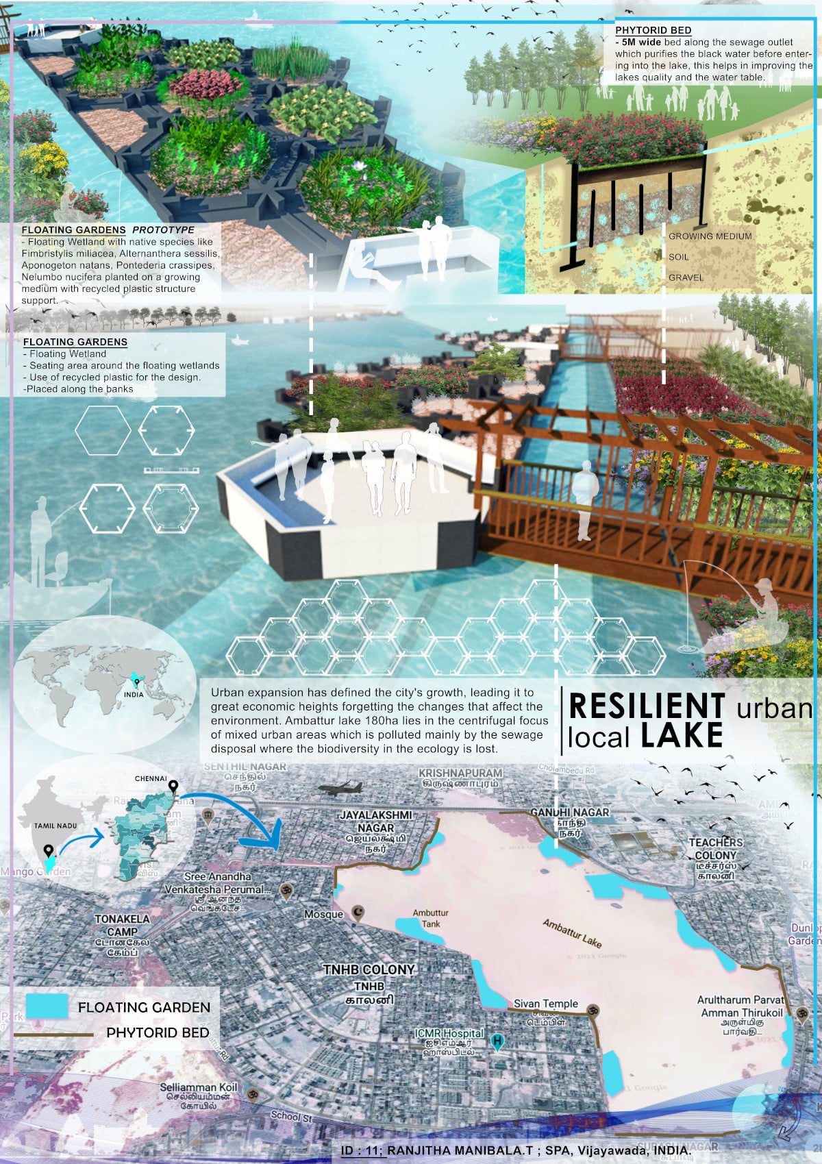
Resilient Urban local Lake
Author: RANJITHA MANIBALA.T
School of Planning and Architecture, Vijayawada
India
India’s fierce blazes arriving at its peak(let’s gather its spot and pieces)
Author: Anushka Arora
School of planning and architecture, Vijayawada-Department : Masters of landscape architecture
India

Indian backwoods are getting increasingly more powerless against woodland fires because of the cruel summers, sporadic precipitation and long droughts which are generally actuated by the evolving environment.
Envisaging Resilience on Cultural Landscape in an Urban Context Based on Thekkinkadu Maidan, Thrissur
Author: NAJILA MOL
SCHOOL OF PLANNING AND ARCHITECTURE
India

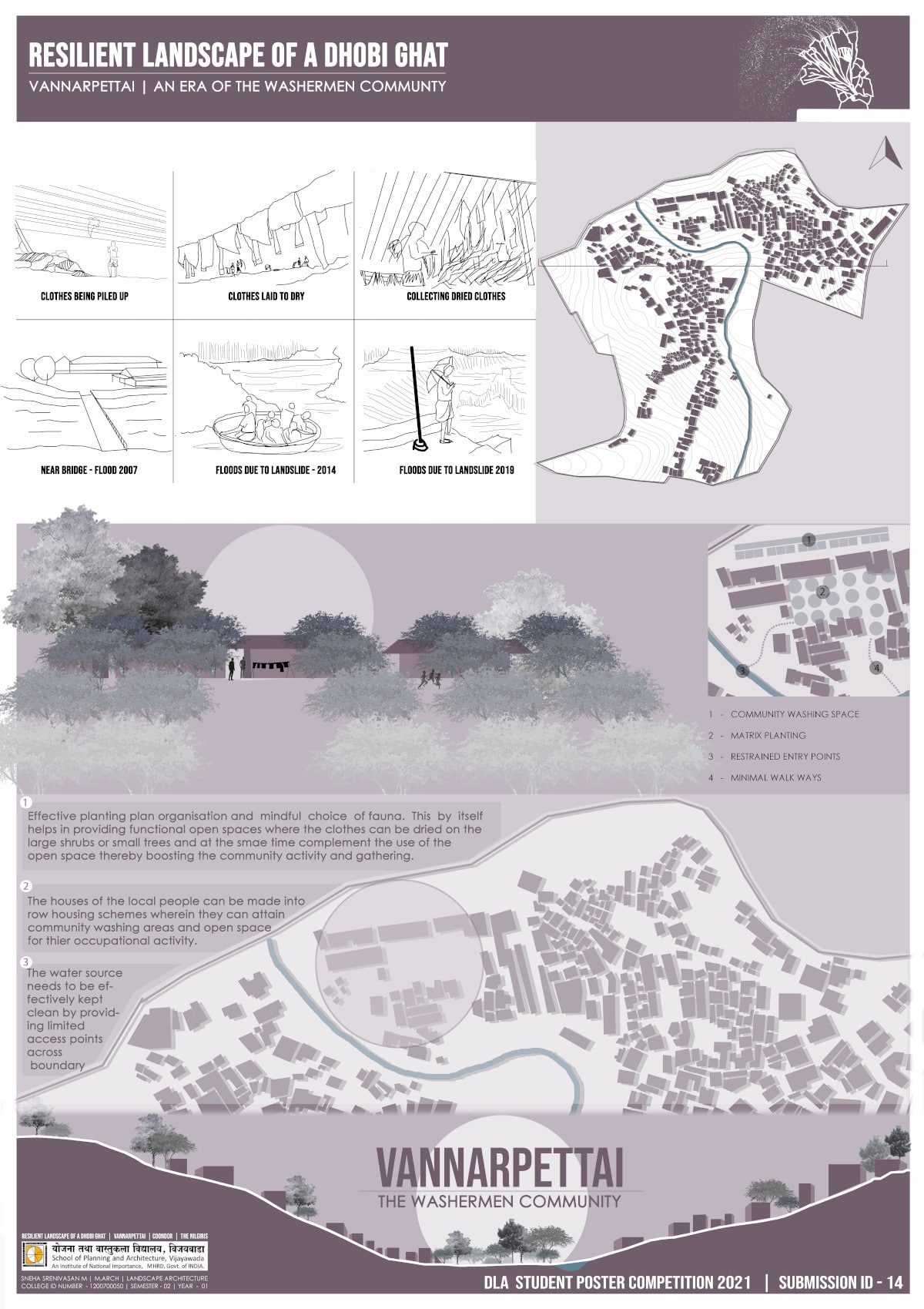
Resilient Landscape of a Dhobi Ghat
Author: Sneha Srenivasan M.
School of Planning and Architecture, Vijayawada
India
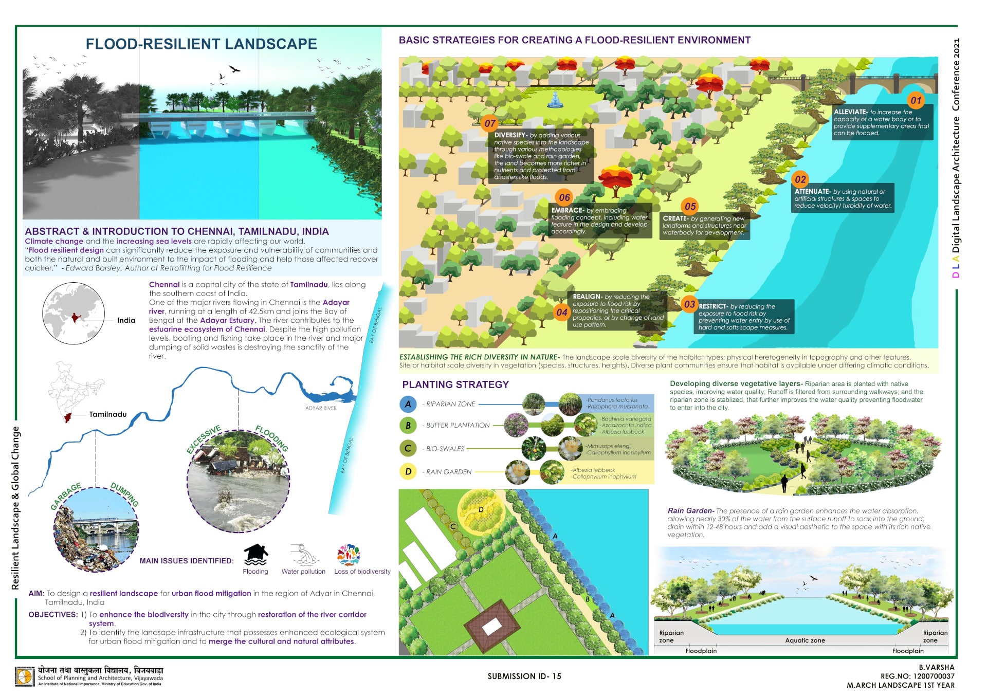
Landscape Design Strategies in Flood-Resilience
Author: Varsha B.
School of Planning and Architecture, Vijayawada
India
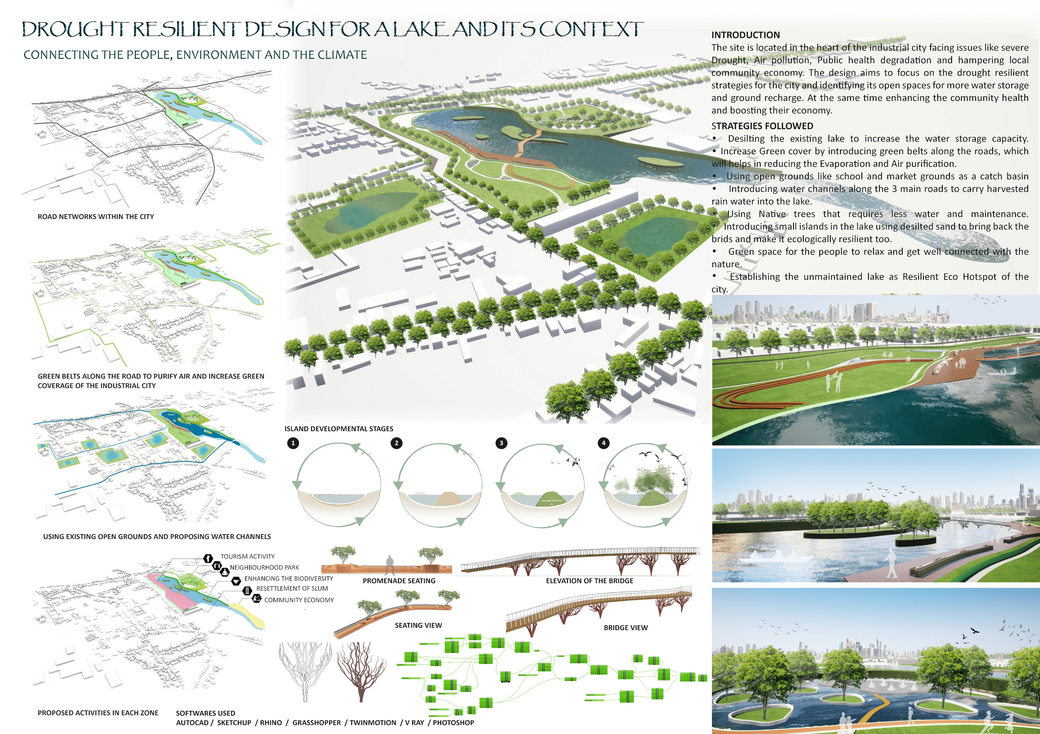
Drought Resilient Design for a Lake and its context
Author: NANDHINI G.
SCHOOL OF PLANNING AND ARCHITECTURE, INDIA
THE SOCIO-CULTURAL BENEFITS OF RETROFITTING STORMWATER CHANNELS TO GREEN CHANNELS: FEASIBILITY STUDY AND DESIGN PROPOSAL FROM JEDDAH CITY, SAUDI ARABIA Special Recognition
Author: Abdulmueen Bogis
Virginia Tech, United States
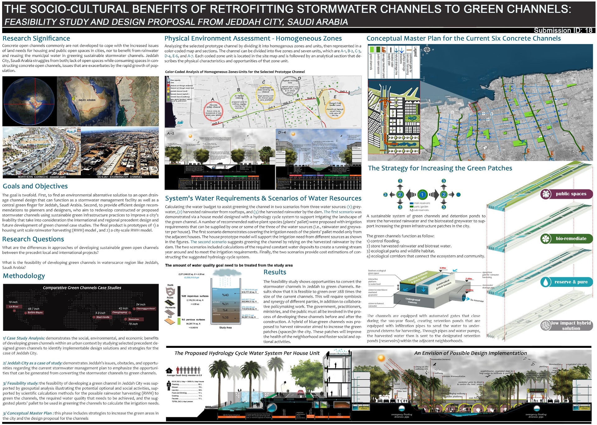
The research project included four phases, 1) Case Study Analysis: demonstrates the social, environmental, and economic benefits of developing green channels within an urban context by studying selected precedent designed green channels to identify implementable design solutions and strategies for the case of Jeddah City, 2) Jeddah City as a case of study: demonstrates Jeddah’s issues, obstacles, and opportunities regarding the current stormwater management plan to emphasize the opportunities that can be generated from converting the stormwater channels to green channels, 3) Feasibility Study: the feasibility of developing a green channel in Jeddah City was supported by geospatial analysis illustrating the potential optional and social activities, supported by scientific calculation methods for the possible rainwater harvesting (RWH) to green the channels, the required water quality that needs to be achieved, and the suggested plants’ pallet to be used in greening the channels to calculate the irrigation needs, and 3) Conceptual Master Plan: includes strategies to increase the green areas in the city and the design proposal for the channels
The feasibility study shows opportunities to convert the stormwater channels in Jeddah to green channels. Results show that it is feasible to green over 288 times the size of the current channels. This will require symbiosis and synergy of different parties, in addition to collaborative policymaking work. The government, practitioners, ministries, and the public must all be involved in the process of developing these channels before and after the construction. A hybrid of blue-green channels was proposed to harvest rainwater aimed to increase the green patches (spaces)in the city. These patches will improve the health of the neighborhood and foster social and optional activities.
hydrometeorological risk prevention model in Veracruz city
Authors:
- Jorge Lopez, UNAM, Mexico
- Andrea Calderón, UCA, El Salvador

DLA
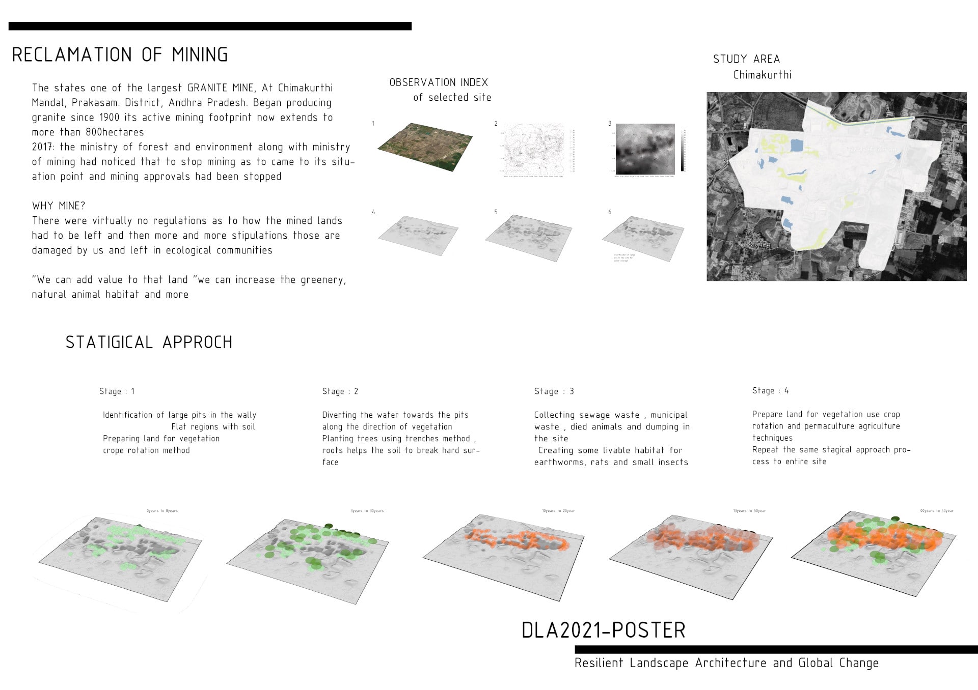
Author: SURENDRA BABU GANTENAPATI
India
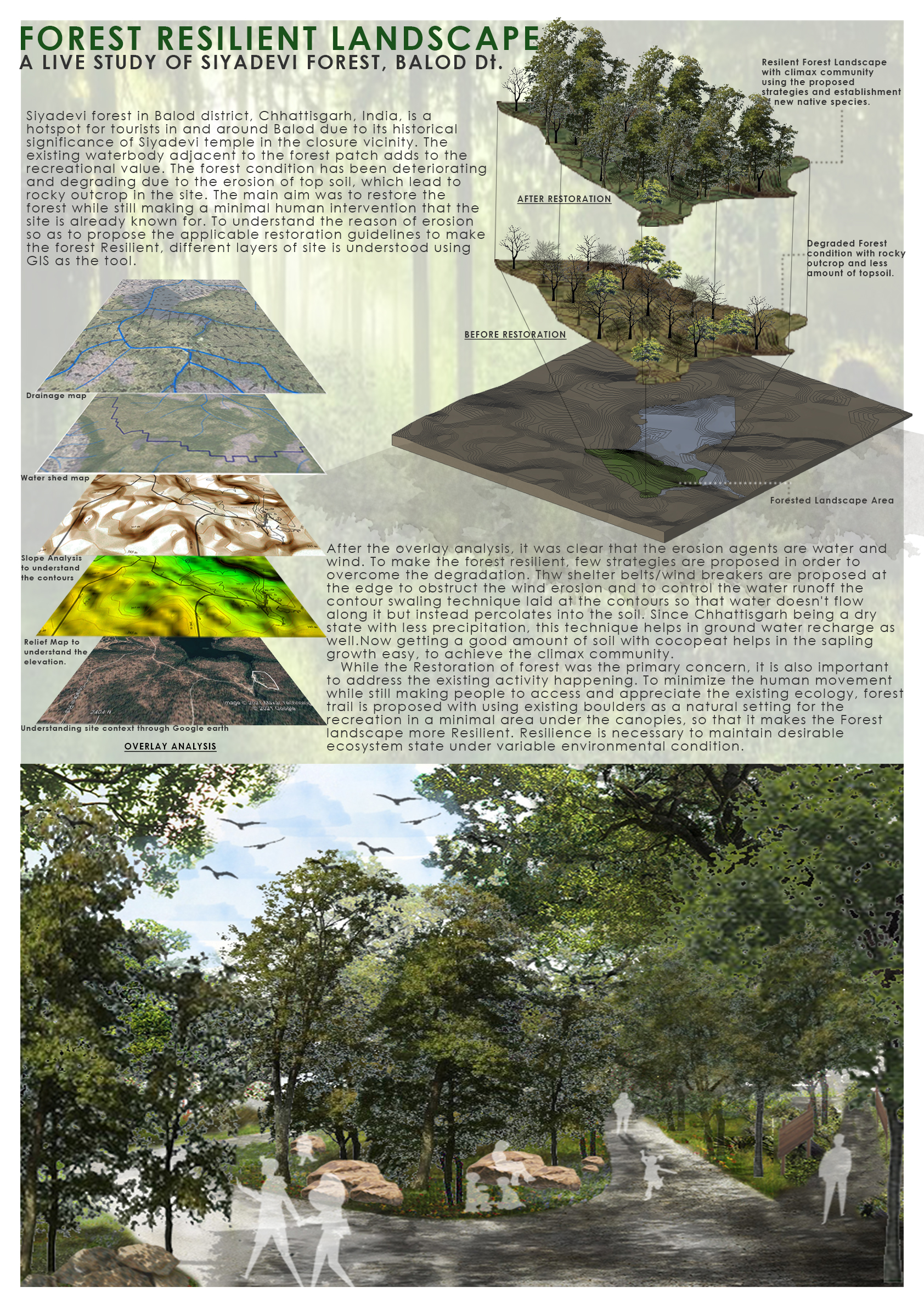
Forest resilient landscape
Author: Thanmayee Auduru
School of planning and Architecture, Vijayawada
India
Riparian Restoration of Morar River, Madhya Pradesh, India
Authors:
- Luvditya Khurana, School of Planning and Architecture, Vijayawada, Andhra Pradesh, India
- Prabhsharan Singh Rooprai, School of Planning and Architecture, Bhopal, Madhya Pradesh, India
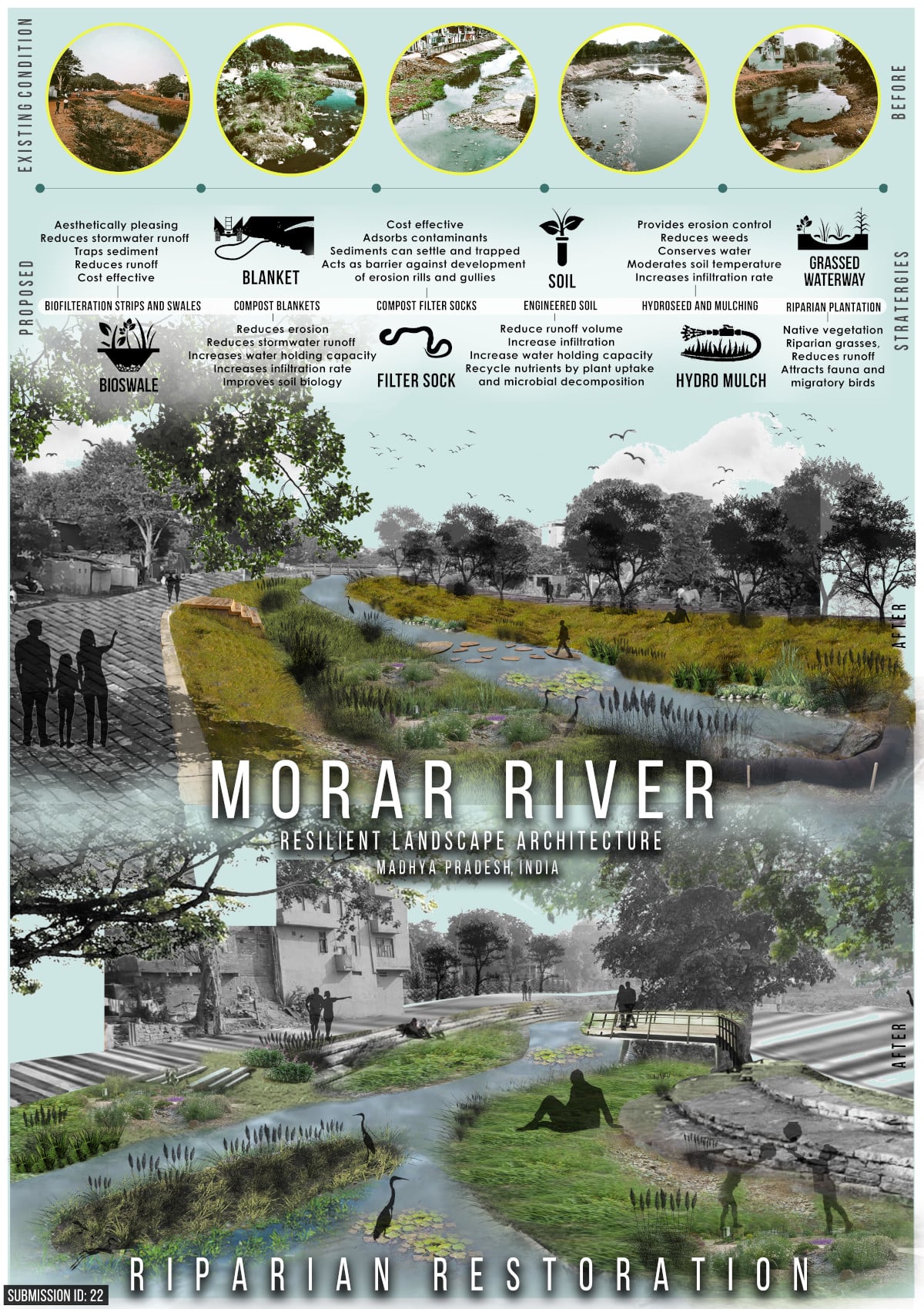
It is necessary that immediate action must be made to safeguard the river to guarantee the drawn-out manageability of water assets in general and a resilient approach should be contemplated to achieve the change one needs to see. In a similar endeavour, the poster attempts to propose the riparian restoration of Morar river with the assistance of some cost-effective strategies that can be executed, thereby enhancing the overall condition of the river and bridging the gap between an ecological and social environment.
Detection of Invasive Neophytes using Novel Artificial Intelligence Algorithms: 3rd prize
Authors:
- Nicolas Tobler, OST – Eastern Switzerland University of Applied Sciences, Switzerland
- Raphael Unterer, OST – Eastern Switzerland University of Applied Sciences, Switzerland
- Cengiz Akandil, OST – Eastern Switzerland University of Applied Sciences, Switzerland
- Guido Schuster, OST – Eastern Switzerland University of Applied Sciences, Switzerland

Our newly developed AI algorithms make it possible to detect Solidago gigantea coverage from simple RGB aerial drone imagery alone.
As drone imagery becomes increasingly ubiquitous, techniques such as the proposed algorithms enable fast, cheap and accurate neophyte detection.
The algorithms process orthomosaic images to generate the detection outputs seen in this poster.
The software is generic, and hence can include additional layers, such as multispectral imagery and/or digital surface models, leading to even better results.
In this work, several algorithms have been developed, including a custom deep convolutional neural network and an innovative semi-supervised clustering approach.
The custom deep convolutional neural network is a fully convolutional architecture which gives a probability distribution output per pixel.
On our test dataset, this setup achieves an accuracy of 90.0% using RBG only or 97.6% using all bands.
As labels are often rare, the semi-supervised approach extracts features from superpixels and clusters them in an unsupervised fashion.
The labels are only used to determine which unsupervised class belongs to which predefined class, which leads to an accuracy of 94%.
This poster shows a coposite image of all input layers (RGB, multispectral, digital surface model) and the resulting predicted outputs.
The underlying image is from the Entensee in Kaltbrunn, Switzerland, where Solidago gigantea is common.
Three different output classes and the corresponding labels have been defined, Solidago gigantea (red), reed (green) and the rest (blue/yellow).
The preliminary results clearly indicate the high effectiveness of the proposed solution for identifying Solidago gigantea coverage.
Since the algorithms perform well with RGB data alone, numerous potential applications using crowd-sourced data may emerge, utilizing variants of the proposed schemes.
Improving Success with Bioengineering
Author: DIVYA RANI
School of Planning and Architecture, Vijayawada, India
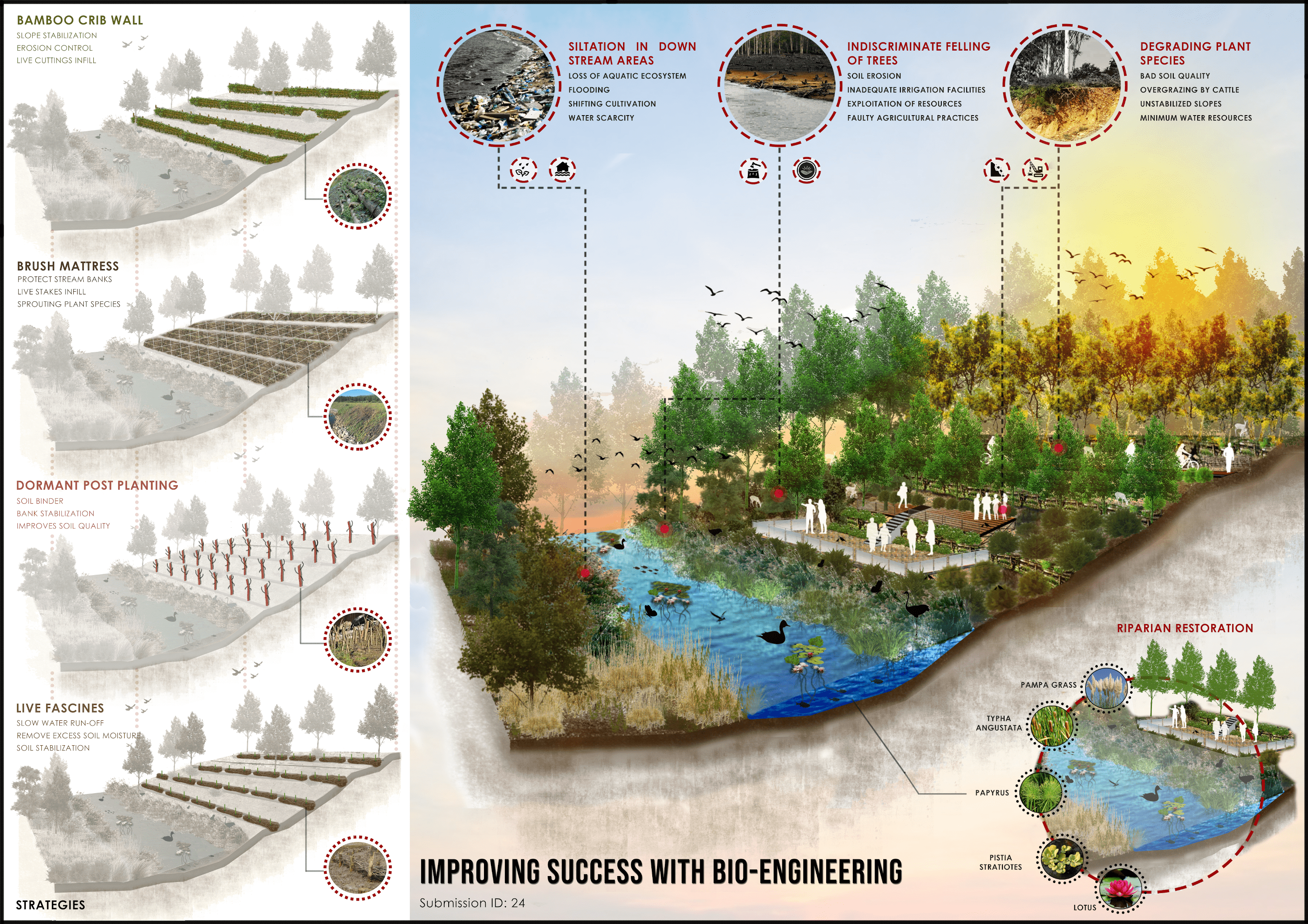
Resilient landscape helps to backfit our communities, so that they could recuperate fast from any natural or man-made disaster. The problems were identified at the site i.e., soil erosion, the weak root system of plant species, degraded water quality, and loss of aquatic ecosystem. Erosion can be caused by natural factors such as channel migration or human activities such as shoreline development. There are multiple methods used to reduce erosion. One option is using heavy machinery but it is very costly. That’s why bioengineering methods have been introduced which will not harm the environment. These methods are cost-effective and could be understood by the local community as well. Many locally available materials are used i.e., Bamboo, willow stem sticks, and live stakes. All these techniques are done manually by laborers. It saves time and creates a long-lasting effect in bringing back the lost biodiversity.
About 64.2% of the land is degraded in hilly regions of India and yet no efforts are being made to rectify it. By selecting this small prototype of an area of nearly 5 acres, around 4.5 acres of land is revitalized by applying bio-engineering principles which led to attract an ample number of aquatic species, flying insects, wildlife habitat, and migratory birds. It helped in saving many endangered species. If 5 acres of land can bring this much change, imagine how our mother earth is going to heal when this huge percentage of degraded land will be treated efficiently and the whole ecosystem will be revived.
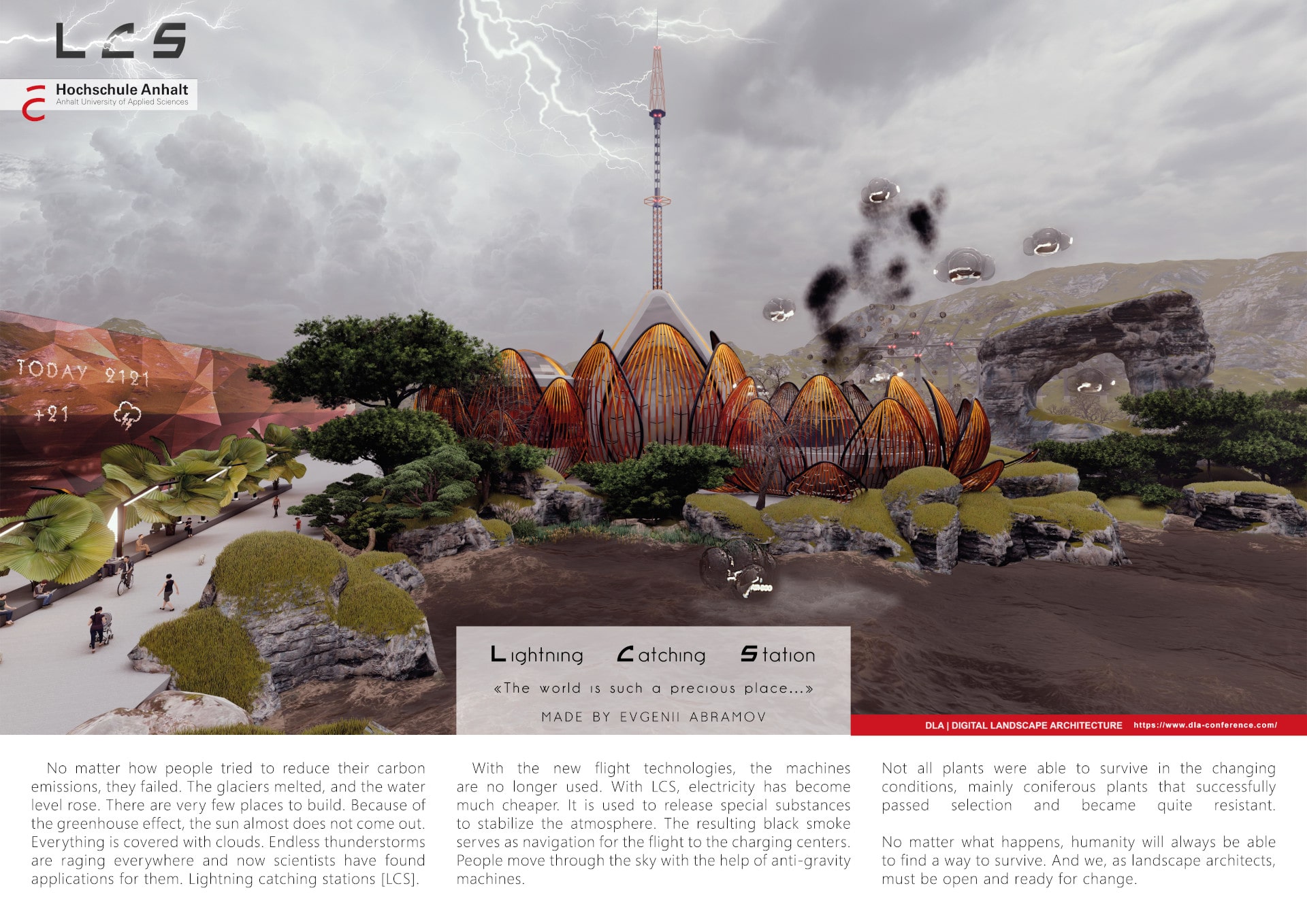
LCS 2121 High score by visitors’ vote
Author: Evgenii Abramov
Hochschule Anhalt
Germany
Uncovering the Design and Planning of an Ancient Urban Landscape in Chiapas, Mexico
Authors:
- Alexandra Bazarsky, Brandeis University, United States
- Pamela García, Universidad Nacional Autónoma de México, Mexico
- George Van Kollias III, Brandeis University, United States
- Josh Schnell, Brown University, United States
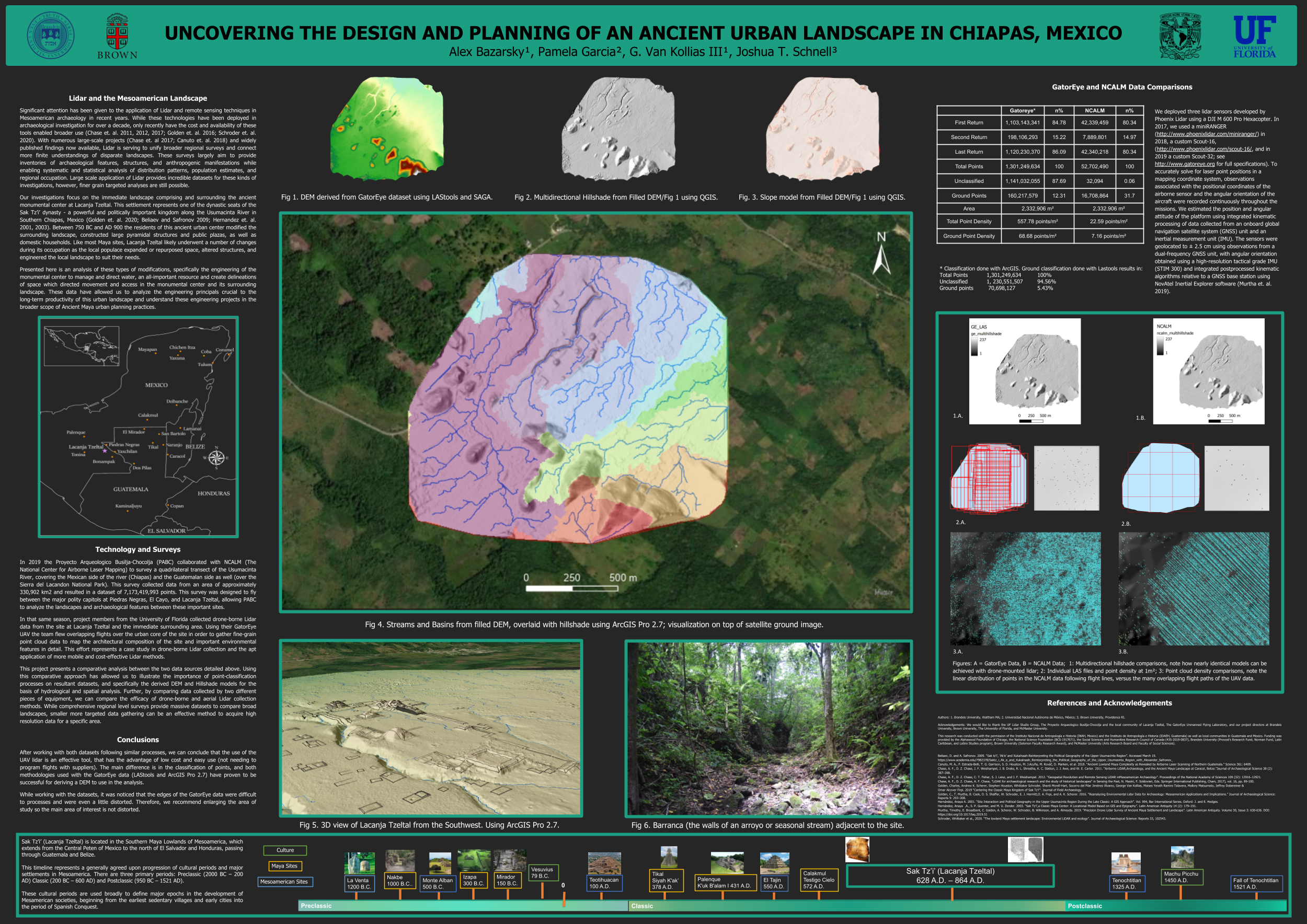
Our investigations focus on the immediate landscape comprising and surrounding the ancient monumental center at Lacanja Tzeltal. This settlement represents one of the dynastic seats of the Sak Tz’i’ dynasty – a powerful and politically important kingdom along the Usumacinta River in Southern Chiapas, Mexico (Golden et. al. 2020; Beliaev and Safronov 2009; Hernandez et. al. 2001, 2003). Between 750 BC and AD 900 the residents of this ancient urban center modified the surrounding landscape, constructed large pyramidal structures and public plazas, as well as domestic households. Like most Maya sites, Lacanja Tzeltal likely underwent a number of changes during its occupation as the local populace expanded or repurposed space, altered structures, and engineered the local landscape to suit their needs.
The third vision: measurable street-scape & a quantitative design guideline: 1st prize
Authors:
- Yuehui Du, Columbia University,GSAPP, United States
- Xun Liu, University of Virginia, United States
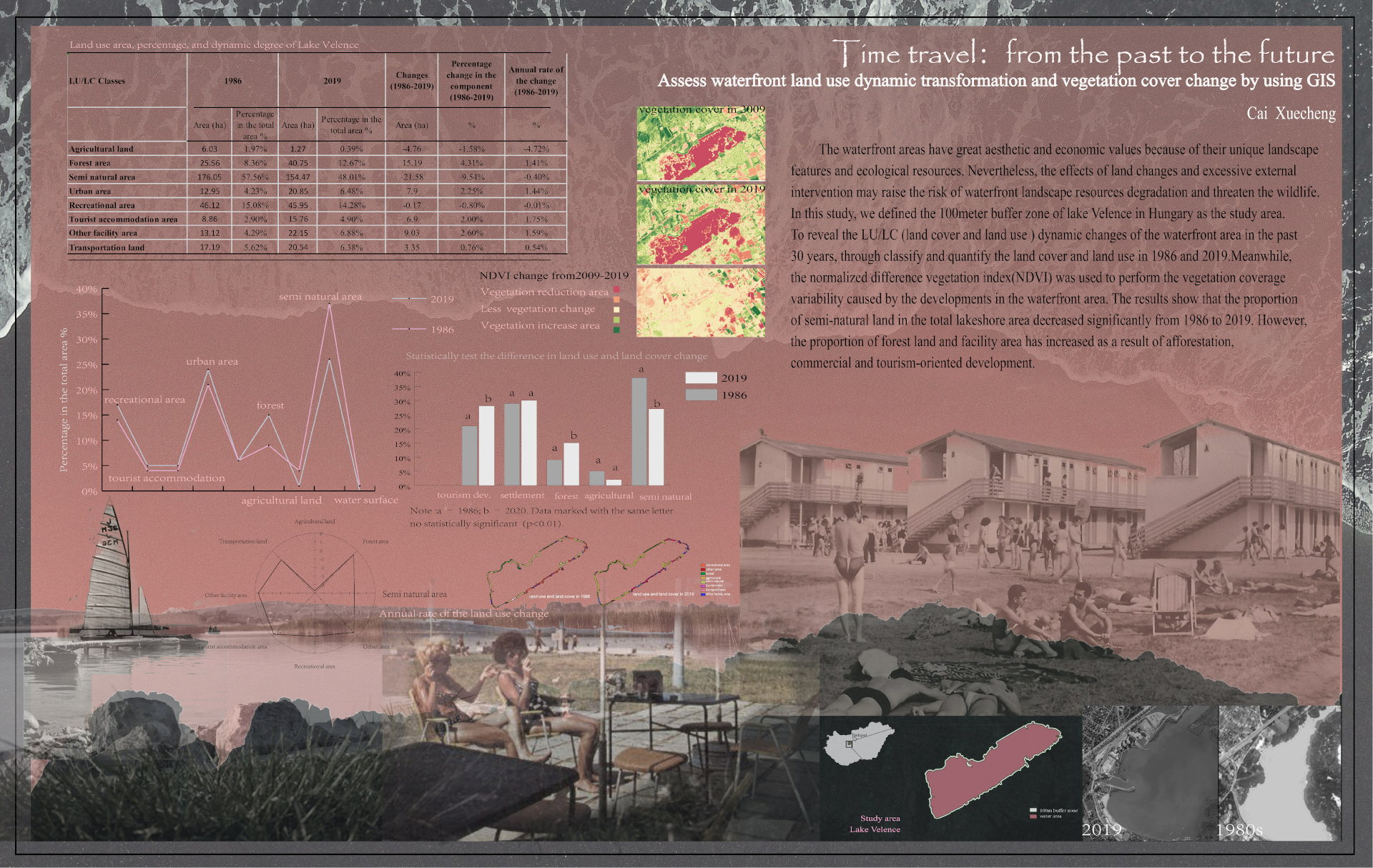
Assessing waterfront land dynamic transformation and vegetation cover change by using GIS
Author: Xuecheng Cai
Szent István University, Hungary
Flood Resilience in agricultural fields
Author: Divya Gayatri
School of Planning and Architecture, Vijayawada, India
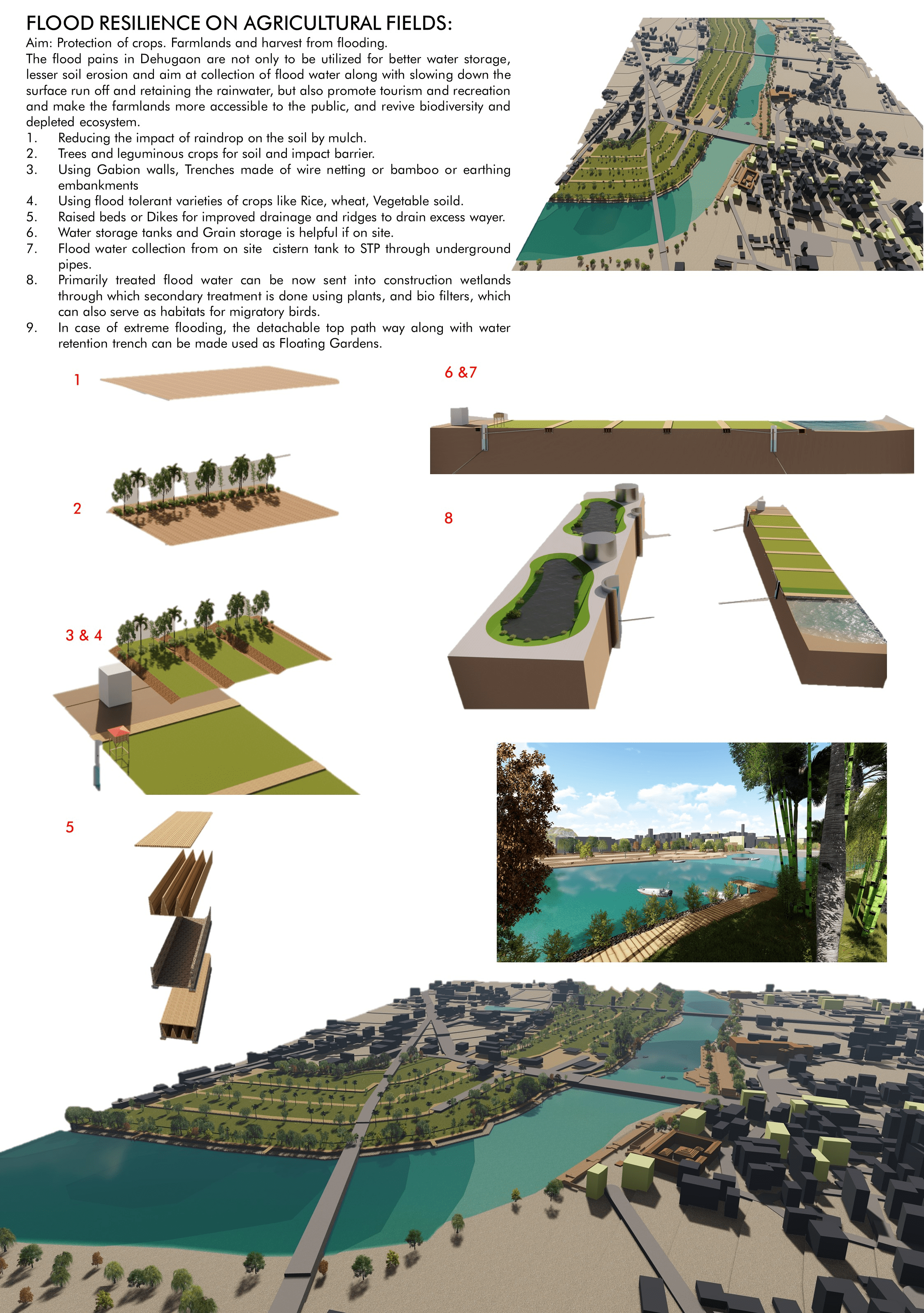
the ground is unable to drain the water fast enough. It is important that
crops and agricultural fields are protected from flooding, in areas that are vulnerable to flooding. The site is located along the flood plains of the Indrayani river in Dehugaon, Maharashtra, India. The town in which the site is located is known for its temples and landmarks of a celebrated saint Sant Tukharam for his literary works and poetry during the Bhakti movement. One bank of the river has Ghats and temples with many cultural practices and livelihood practices going on. The flood plains on the opposite bank have farmlands and scrub vegetation. The biodiversity is greatly depleted due to polluted river water. During the rainy season, Dehu gaon suffers from flooding of the Indrayani river and the 25years high flood line can completely get flooded during flash floods. Hence several Strategies to prevent soil erosion, crop damage, promote floodwater harvesting, floating gardens, natural methods to treat water are proposed. The aim is to prevent floods from causing major property, crop, and harvest damage and use them to our advantage in the future.
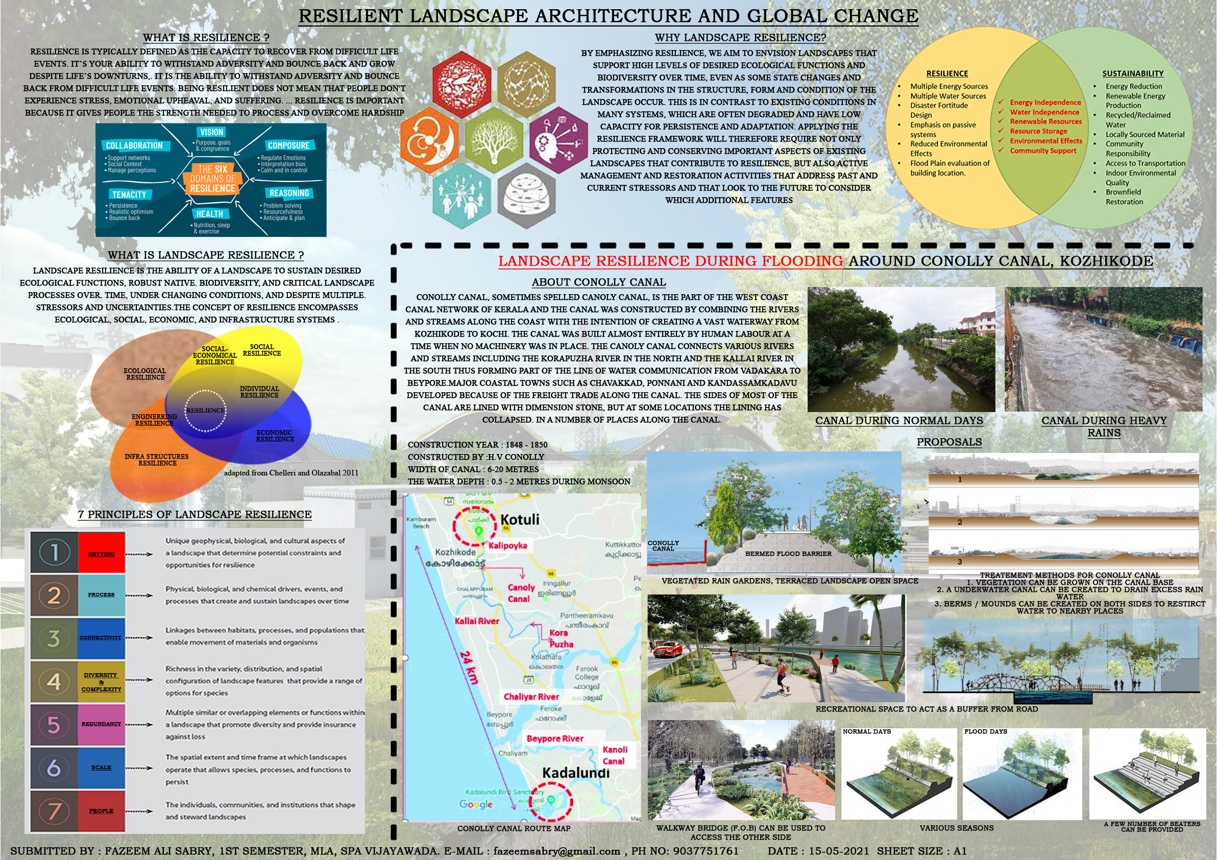
Flood Resilience Landscape Architecture
Author: Fazeem Ali Sabry
SPA, Vijayawada, India
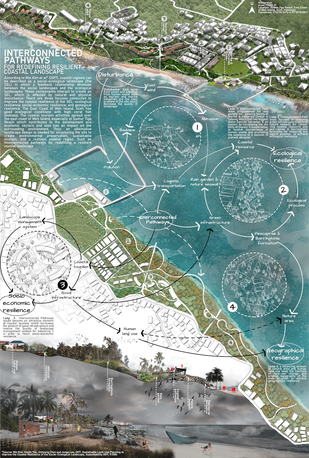
Interconnected Pathways for Redefining Resilient Coastal Landscape
Author: Mustofa Kamal
Indonesia
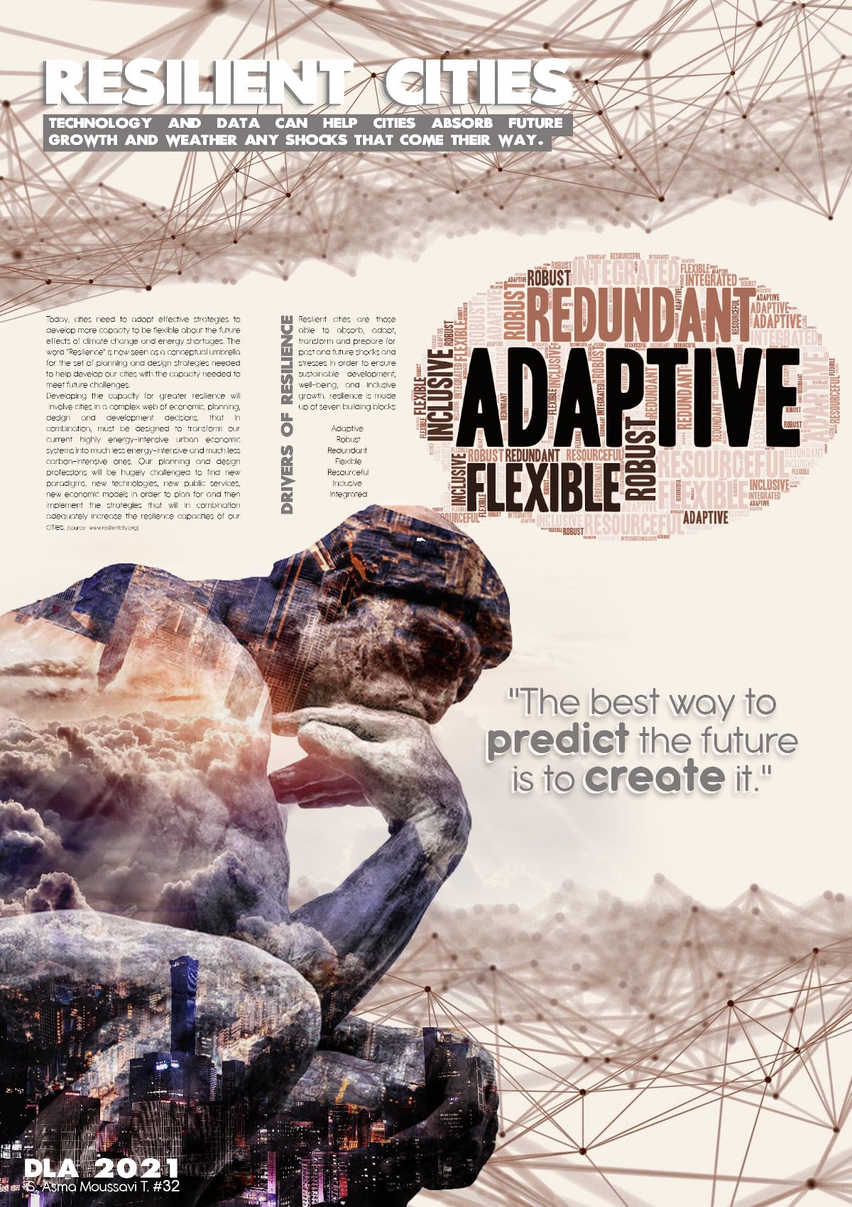
Resilient Cities Second highest score by visitors`votes
Author: Seyedeasma Moussavitorshizi
Hochschule Anhalt, Germany
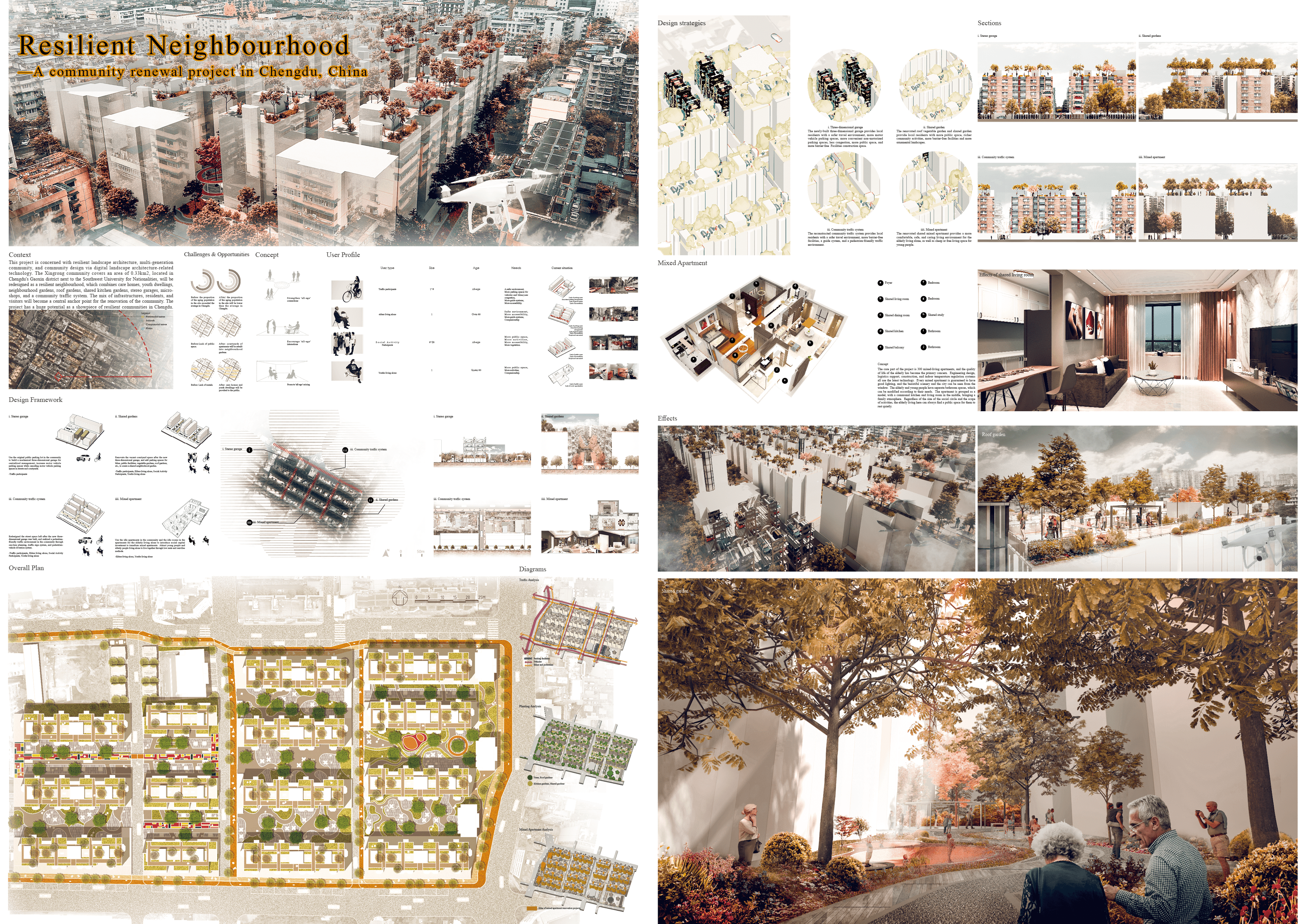
Resilient Neighbourhood
Authors:
- Qingyang Gan, Chengdu Polytechnic, China
- Jie Jiang, Chengdu Polytechnic, China
- Jingyu Li, Chengdu Polytechnic, China
- Lei Sun, Chengdu Polytechnic, China
REAL PLEASURE GARDEN: THE APPLICATION OF STYLEGAN MACHINE LEARNING MODELS FOR GARDEN DESIGN
Author: Austin Lu
United States
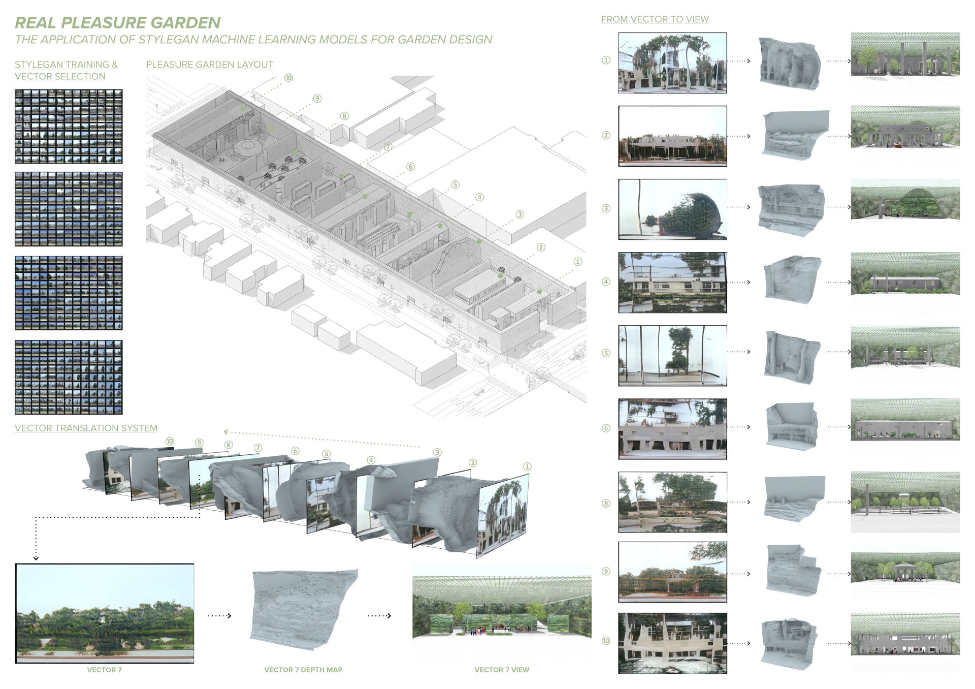
The design concept of the garden was inspired by the customized StyleGAN machine learning model trained on Runwayml.com. The model was trained based on 900+ images from artist Edward Ruscha’s street images. The StyleGAN model generated many visual elements similar to the input images. The vectors were sequenced into 10 individual rooms for different uses. The depth map was further distilled from the vector images in Rhino and was transformed into scenes that imitated the original StyleGAN vector drawing.
Shire of wind farm: future wind farm planning driven by analytical geo-spatial data High score by visitors’ vote
Author: Zhuocheng(Jackie) Gu
RMIT University, Australia
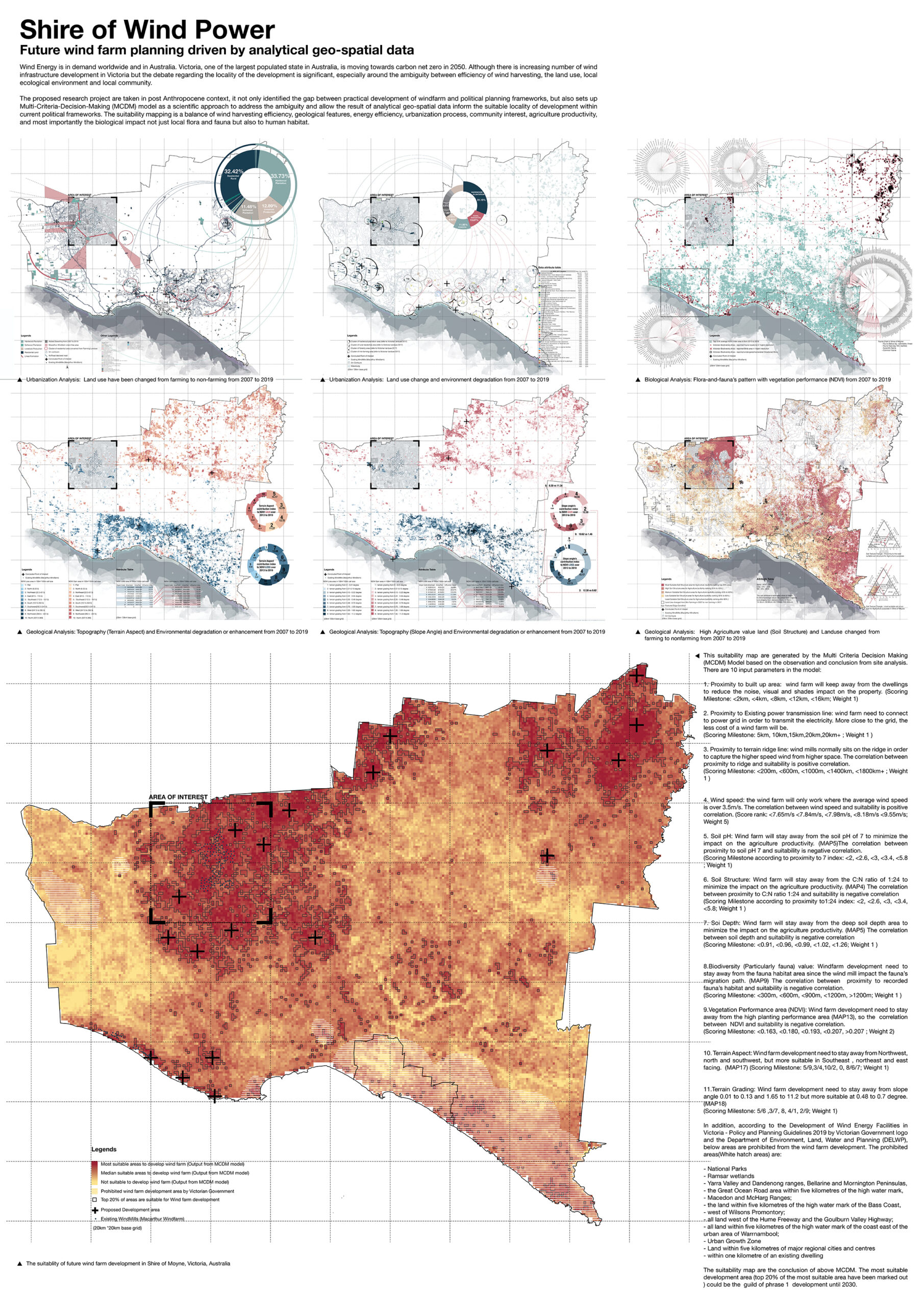
The proposed research project are taken in post Anthropocene context, it not only identified the gap between practical development of windfarm and political planning frameworks, but also sets up Multi-Criteria-Decision-Making (MCDM) model as a scientific approach to address the ambiguity and allow the result of analytical geo-spatial data inform the suitable locality of development within current political frameworks. The suitability mapping is a balance of wind harvesting efficiency, geological features, energy efficiency, urbanization process, community interest, agriculture productivity, and most importantly the biological impact not just local flora and fauna but also to human habitat.
Measuring Landscape Connectivity in Northwest Chatham County, Georgia, USA Special Recognition
Author: Jiyue Zhao
University of Georgia, United States

Mangroves …The shorekeepers
Author: Mansi Mhatre
School of Planning and Architecture Vijayawada, India

Mangroves are very gainful biological systems, offering basic types of assistance that advantage us. They are home to a unimaginable exhibit of species, mangroves are biodiversity areas of interest. They give settling and rearing environment to fish and shellfish, transitory birds, and ocean turtles. The conservation of mangroves is an important factor.
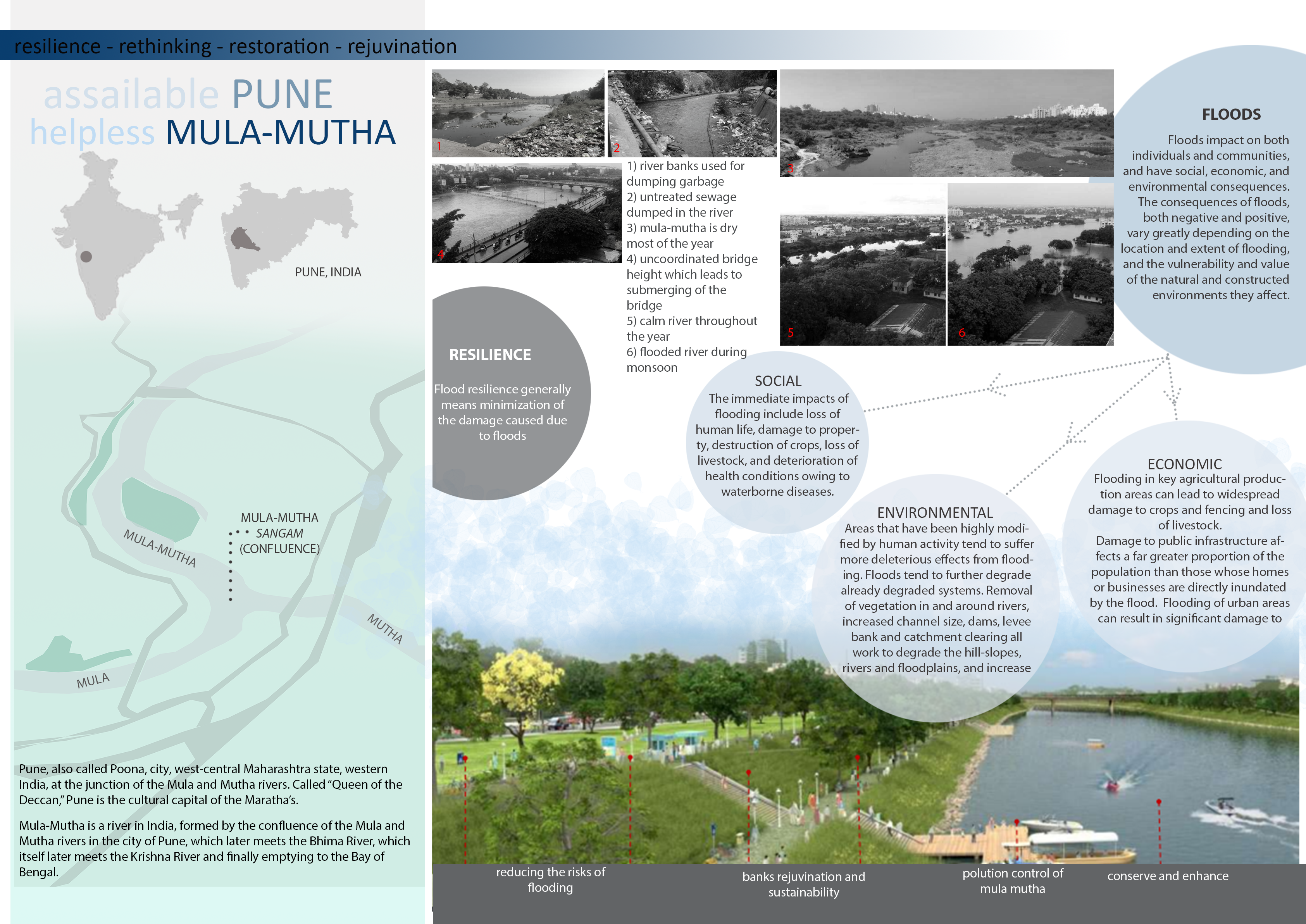
FLOOD RESILIENCE IN MULA-MUTHA RIVER,PUNE,INDIA
Author: PRATIKSHA TOMAR
School of Planning and Architecture Vijayawada, India
Wolfsburg Resilient City as a Climate Garden, City Space History + Digital Landscape Architecture Special Recognition – highest score by visitors`vote
Author: Esha Kundu
Hochschule Anhalt, Germany

Much is in our hands to stop our own climate from changing. Changes to the environment, built and landscape need sensitive approaches to revert from the evident symptoms of drying landscapes leading to temperature rise and loss of biodiversity. At present, several ecological links are at brink that need immediate attention in terms of self-sustaining methods to safeguard sound continuity of life processes. This research aims at rediscovering the landscape assets in today’s context, green models of antiquity such as cultural landscapes that have proved to be the means of self-sustenance for generations, but in the due course of time, the very assets have either vanished or diminished remaining as separate entities, with the aspects of culture and landscapes being deviated, transforming cities greatly giving a new face.
Wolfsburg is one such example. Among the newly founded cities of 20th century, its origin dates back to 942 AD. An ever evolving city has a rich history, is noteworthy for the several faces it holds in its timeline of city transformation. Lately, the city’s growth has been parallel to the emergence of Volkswagen factory from individual auto production facilities into a globally active company that makes it closely associated to be known as the automobile city of today. Amidst its evolution, the natural setting of Wolfsburg cannot be ruled out in early years of its formation. What makes it special are the cultural landscapes together with many castles that embellish its heritage, out of which from Wolfsburg Castle (1302 AD), the city draws its name. Amidst the flourishing side of the automobile industry in Wolfsburg, since 50 years after the high point of post – war modernism, a rapid transformation has been observed evident of leaving voids within the city. Metaphoric of a green thread (landscapes) that stitched history, architecture together with urbanity, today leaves a major disconnection with the historical landscapes in regard to resilience and sustainability. With the wake of modernization, the very historical landscape faces immense threat of being disregarded. The analysis reveals an important evidence, Wipper Teich, an erstwhile pond erased from the face of Wolfsburg. Plunging water table underneath due to diversion of streams has wiped off the inlets feeding the pond. Besides offering a massive volume for natural rainwater harvesting, Wipper Teich was also a major source of sustenance for the neighborhoods being the largest reservoir of fishes.
Goal
With the example of Wolfsburg, the main goal of this research is to come up with landscape design solutions/ interventions in the light of technology that will help regard these assets as crucial elements of sustenance. The specific contribution of this research is to make Wolfsburg futureproof, can be achieved by focusing on the very cultural landscapes at first that are under constant threat of erosion, thereby reinvigorating the missing links, recreating ecological networks intrinsic to any landscape, identifying potential sites to demonstrate design transformations that can become generic models, making it highly potent city of the future divulging hidden layers and stitching back the city in green thread with help of the needle of technology. Thus, envisioning Wolfsburg to be a green, smart (innovative), sustainable, culturally rich city.
Scope
The scope of this research is limited within boundaries of Wolfsburg city, however boundaries are not adhered when it comes to understanding natural systems and their phenomena. Several scales will delve deeper into identifying appropriate technological methods that will help enhance man and nature interactions.
Methodology
A research methodology that comprises landscape design interventions at several scales backed with a strong analysis of history and visions of digital landscape architecture in context of Wolfsburg and its environs. Inspirations are drawn from the innovative concepts on ‘smart’ aspects of city and landscape ensuring durability for future.
Expected outcome
Envisioning a historic city of the future, strengthening the face of Wolfsburg in the light of landscape assets that the city is naturally bestowed with, for example decentralized measures of rainwater management, green areas, permeable surface paving, green roofs, bio-luminescence and native tree species as a new path finder and a highlight replacing street lights. The idea is to strengthen the very cultural dynamism of Wolfsburg that has the potential to become a “model city”, is livable, human, 15 – minute walkable, futuristic ensuring resilience to calamities, conceptualized on the foundations of sustainability. The research not only identifies cues from history, but also resonates on making the city intelligent, empowering spaces with smart systems offering manifold experience and uses for the public. To ensure longevity of the envisioned transformations, maintenance of landscapes is equally important, hence the research further explores documentation and transmission of landscape transformations with the help of GIS and 5G technology to anticipate their upkeep and preservation.
For instance, the envisioned climate gardens will be equipped with technology for documenting plant processes, growth patterns, monitoring network development, energy transfer that could be an interesting activity, can be a medium of teaching in several educational institutions as well as for concerned public. Drawing inspirations from the case studies, the research further reflects more such ideas that strengthen the experiential aspect of the designed green spaces.
Wolfsburg that originated on the principles of landscape history, transformed into being identified as automobile city of today, is further envisioned to be a resilient city of future, self-sustaining, whereby climate gardens are the intelligent landscape elements, are its precursors, new green cores that belong to the new green typology following Angars and allotment gardens lineage. Together with existing allotment gardens, climate gardens are envisioned to be the new green utopian ideal (network of greens) that shall function not in isolation, but in coordination with all systems within the city blended.
Energy Landscape of the Oss Region Special Recognition
Author: Kitti Biró-Varga
Wageningen University & Research, Netherlands
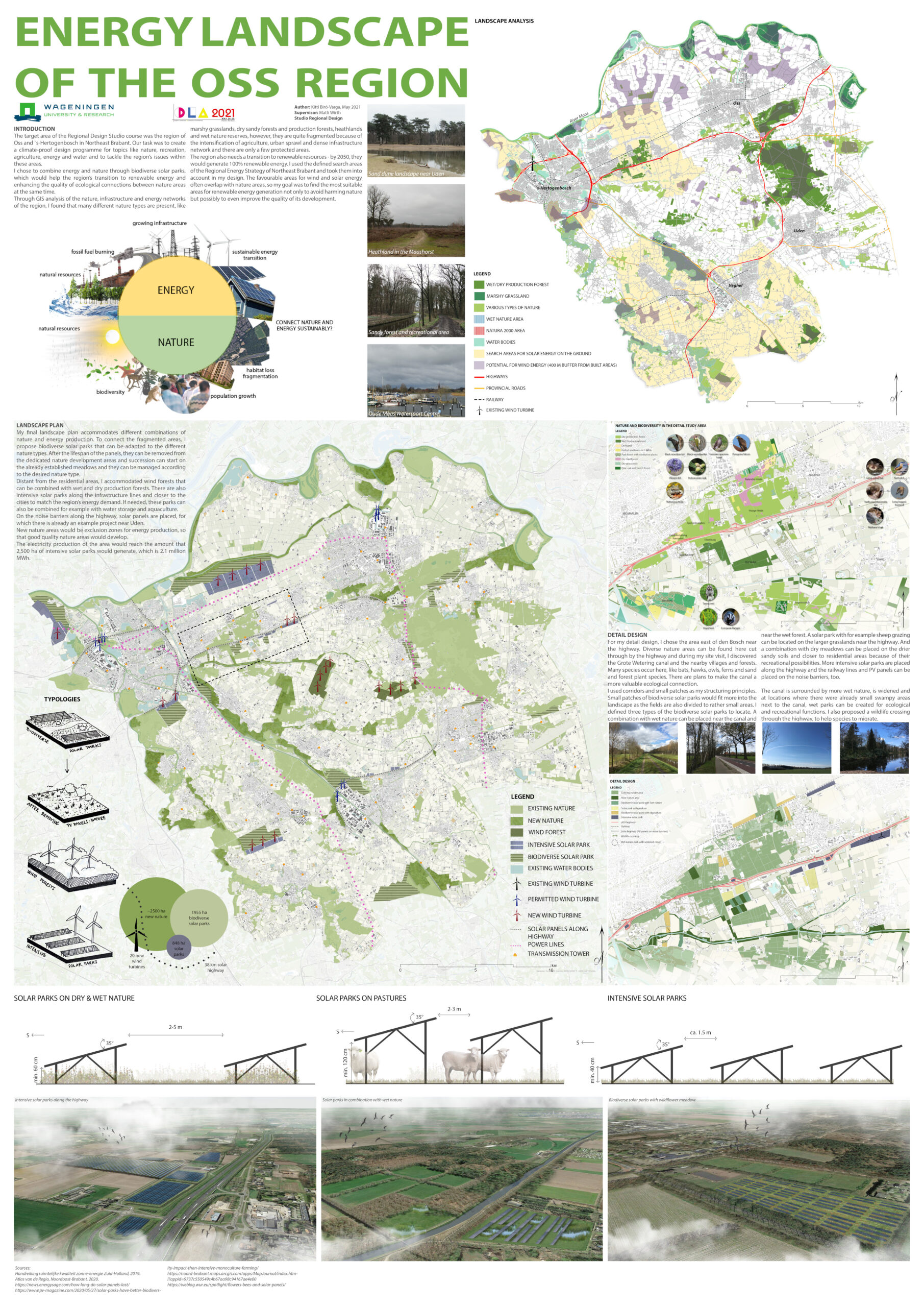
There are ways to connect nature and energy sustainably and one of them are biodiverse solar parks which can be combined with different types of nature and also with agriculture. I experimented with some combinations in this project and found suitable areas for this proposal with the help of GIS, field visits and satellite images. More studies still need to be conducted in order to find out the true value of this combination of nature and energy for biodiversity, however, the region of Oss looks like a promising location for renewable energy and nature development.
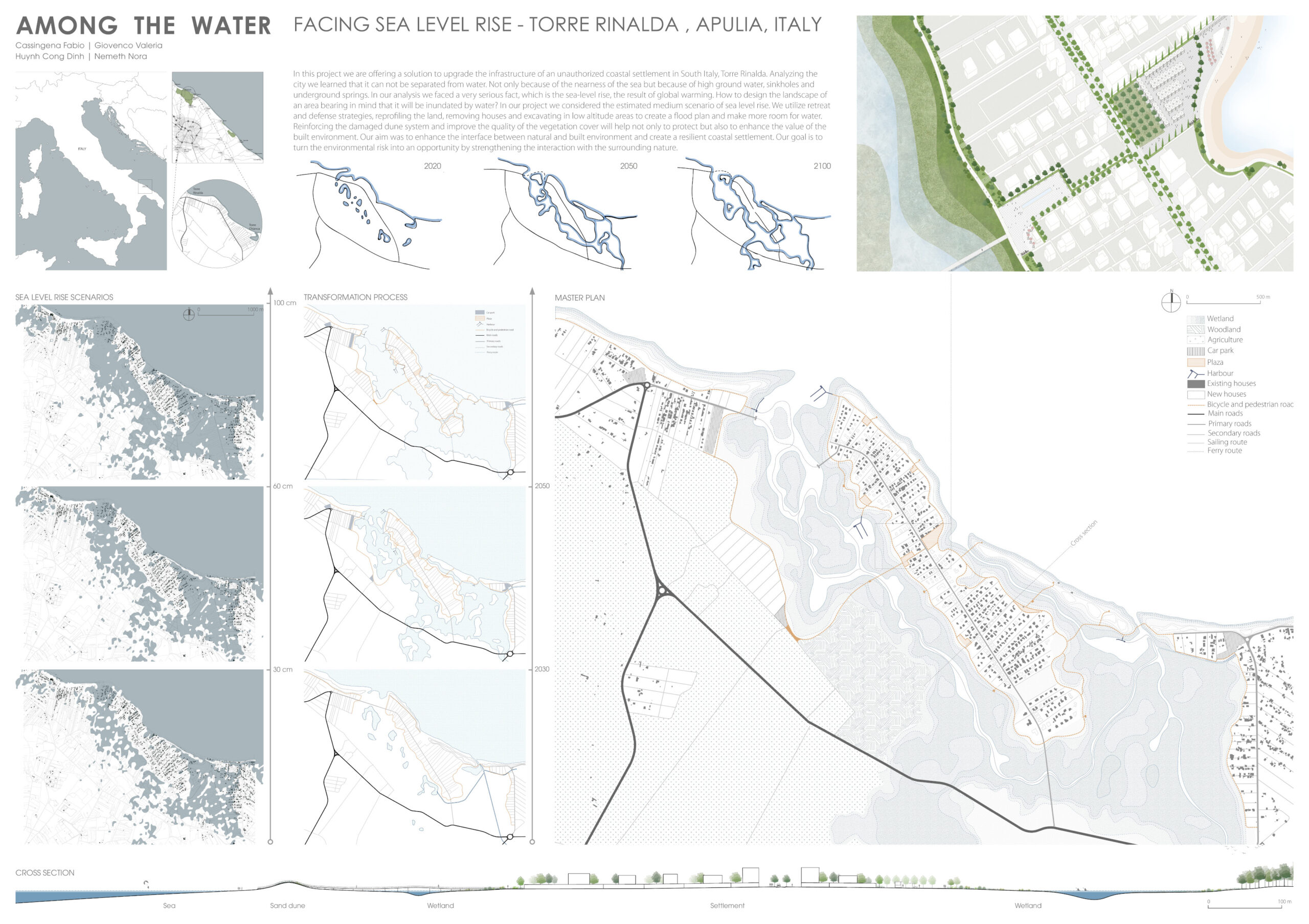
Among the water
Authors:
- Dinh Huynh, Politecnico di Milano, Italy
- Fabio Cassingena, Politecnico di Milano, Italy
- Nora Nemeth, Politecnico di Milano, Italy
- Valeria Giovenco, Politecnico di Milano, Italy
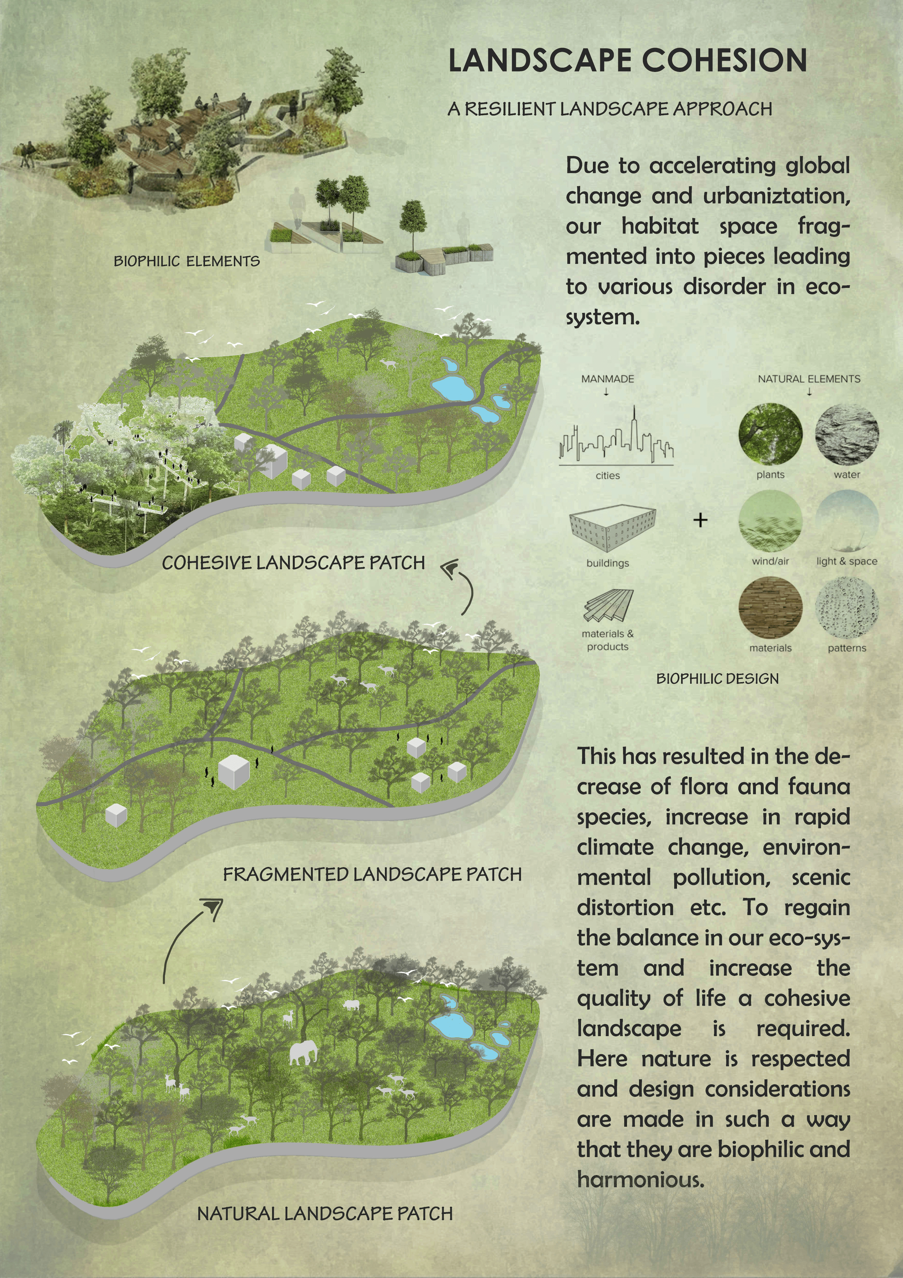
Landscape cohesion
Author: Iswarya S.
School of planning and architecture , Vijayawada, India
CO(R)AL
Author: Witsarut Ditpae
RMIT University, Australia

Hence, around 200 million years before coal exists, in the Paleozoic age, coral originated to occupying the ocean floor covering around 5 million square kilometres.
The coal industry yields a great portion of GDP as Australia is the world’s largest coal -metallurgical and thermal-exporter. Even the trend of Australian coal export earning tends to decline in the last couple of years, contrary to the volume of coal productivity that is raising due to its production growth from new capacity and expansions. Not only the great revenue but also the great amount of carbon dioxide emission that coal industries contribute. 540 million tonnes of co2 emission from the coal industry annually definitely plays a vital role in driving pressure onto the earth and also the ocean to absorb and make a consequence of rising ocean acidification respectively.
Australia’s exclusive economic zone (EEZ) is one of the largest in the world with a total marine area of around 10 million square kilometres which is considerably larger than the 7.69 million square kilometres of the Australian mainland states and territories (geoscience Australia, n.d.).
The Australia EEZ sits on a wide span ranging from tropical to polar climate zones in the southern hemisphere that also renders a broad range of diversity in the area. The coral reef is one of the precious natural resources that offer many beneficial aspects ecologically and economically. Since 1998, the coral reef around the world has been facing bleaching problems and seem to be increased in quantity and intensity as results of global warming assumably driven by economical industries.
However, co2 is not the only agent causing coral bleaching. In the western coast area, the sedimentation, majority from agricultural land use,
Has a notable influence on the health of the coral reef. Sediment can affect coral health in many ways, sedimentation, turbidity and interference with coral photosynthesis and growth.
Coral bleaching not only causes ecological problems but delivers a reaction to others part of Australia EEZ economics as well, for instance, commercial fisheries and tourism industries.
Regarding the concern of the issue mentioned above, this co(r)al visual essay is represented to juxtapose the proximity of the coal mining industry with the precious great barrier reef as representatives for creating a meaningful conversation in order to raise the interrogation of the resolution which balance between the fossil fuel extraction and consumption and the well-being of irreversible ecosystems by setting these two opposing natural resources and examining through the relationship in the realm of climate change.
This set of map records the phenomenon and traces of relevant agents occurring in the area of interest in each scales which hosts numerous significant coral reefs that are a direct victim of this phenomenon.
PORTAL, Way Of Traveling The World
Author: SEOYONG LEE
Seoul National University, Graduate of Environmental Studies, Department of Lancscape Architecture, South Korea

There is a portal system that allows you to move to any area you want, so you can explore new areas at any time. In addition, various interactions have been established in the world so that users can feel that they are experiencing the world, not just looking at the world.
What if We Map the Forest Loss Data of 113 Terrestrial Protected Landscape in the Philippines? Prioritization for Restoration, Conservation, and Preservation through Hansen Global Forest Loss Dataset Special Recognition
Author: Charl Justine Darapisa
Seoul National University, South Korea

A new approach to IoT: evaluating the users’ mental health and well-being in urban landscapes; digital analysis of post-Covid experiences:1st prize
Authors:
- Zahra Shirzadian, Shiraz University, Iran
- Roya Naamipouran, Shiraz University, Iran
- Farshad Akari, Shiraz University, Iran
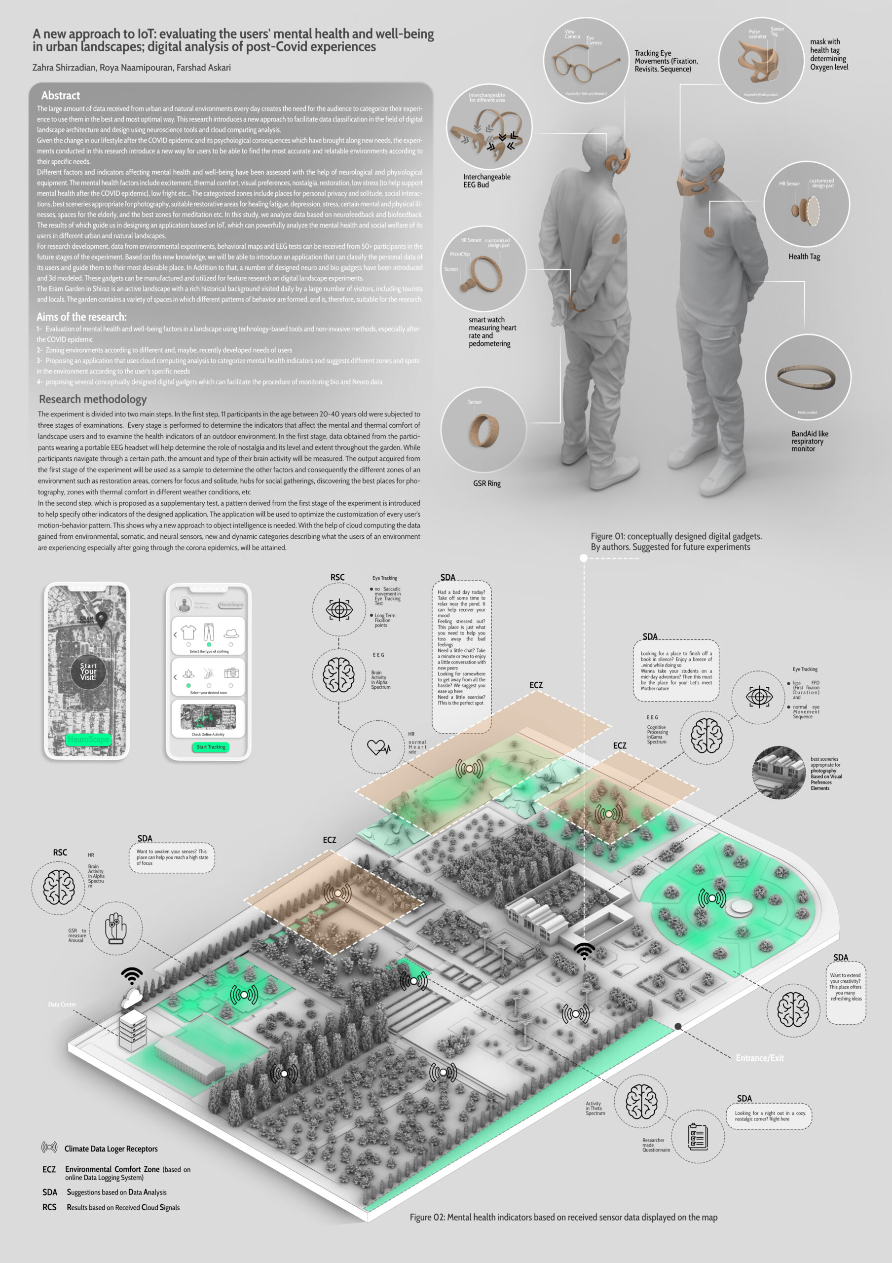
Given the change in our lifestyle after the COVID epidemic and its psychological consequences which have brought along new needs, the experiments conducted in this research introduce a new way for users to be able to find the most accurate and relatable environments according to their specific needs.
Different factors and indicators affecting mental health and well-being have been assessed with the help of neurological and physiological equipment. The mental health factors include excitement, thermal comfort, visual preferences, nostalgia, restoration, low stress (to help support mental health after the COVID epidemic), low fright etc… The categorized zones include places for personal privacy and solitude, social interactions, best sceneries appropriate for photography, suitable restorative areas for healing fatigue, depression, stress, certain mental and physical illnesses, spaces for the elderly, and the best zones for meditation etc. In this study, we analyze data based on neurofeedback and biofeedback. The results of which guide us in designing an application based on IoT, which can powerfully analyze the mental health and social welfare of its users in different urban and natural landscapes.
Aims of the research:
1- Evaluation of mental health and well-being factors in a landscape using technology-based tools and non-invasive methods, especially after the COVID epidemic
2- Zoning environments according to different and, maybe, recently developed needs of users
3- Proposing an application that uses cloud computing analysis to categorize mental health indicators and suggests different zones and spots in the environment according to the user’s specific needs
4- proposing several conceptually designed digital gadgets which can facilitate the procedure of monitoring bio and Neuro data
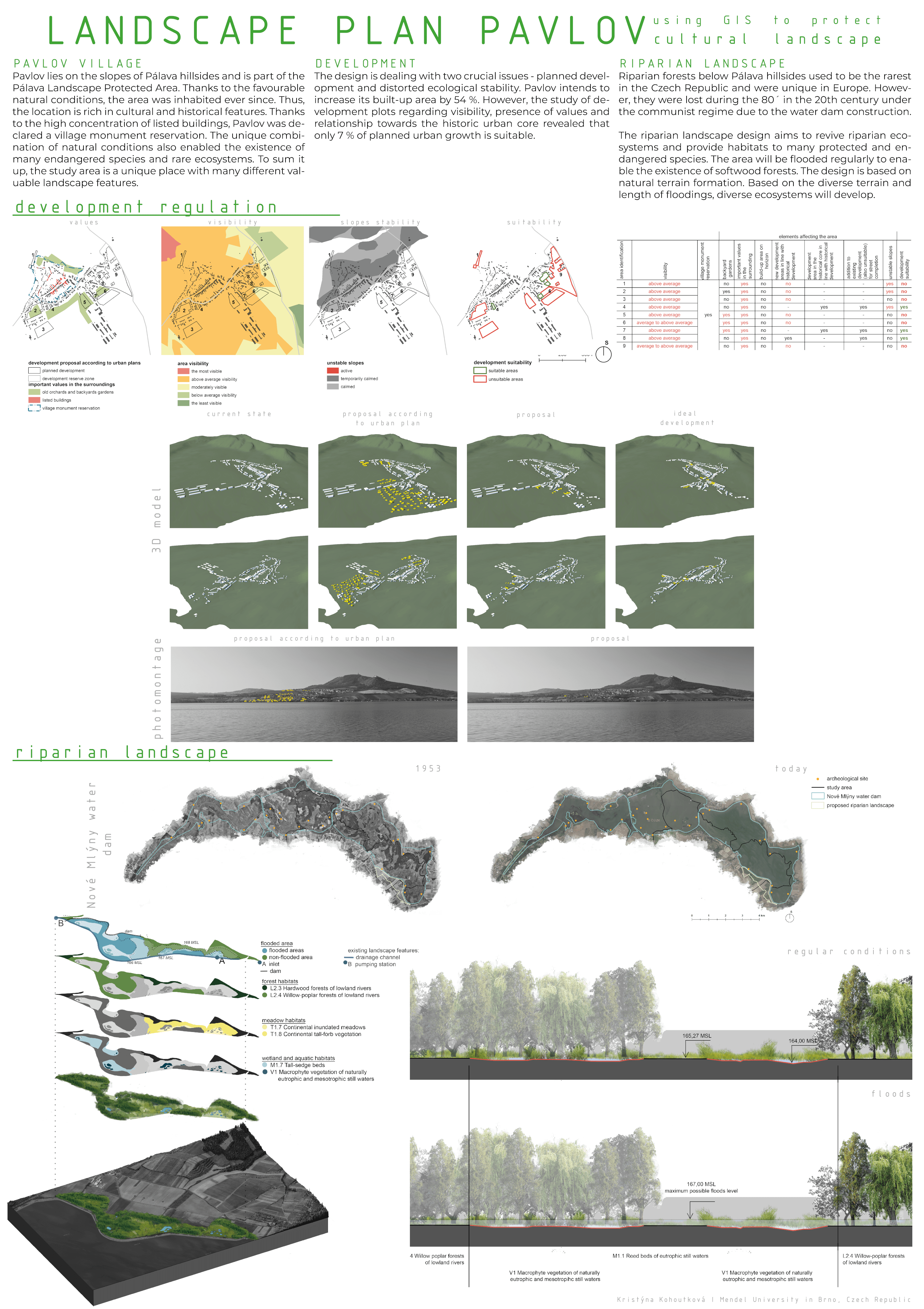
Landscape Plan Pavlov – Using GIS to Protect Cultural Landscape Special Recognition
Author: Kristýna Kohoutková
Mendel University in Brno, Czechia
PARCS, PRO-ACTIVE RECOVERY COMMUNITY STRUCTURES
Author: Sahand Azarby
North Carolina State University, United States
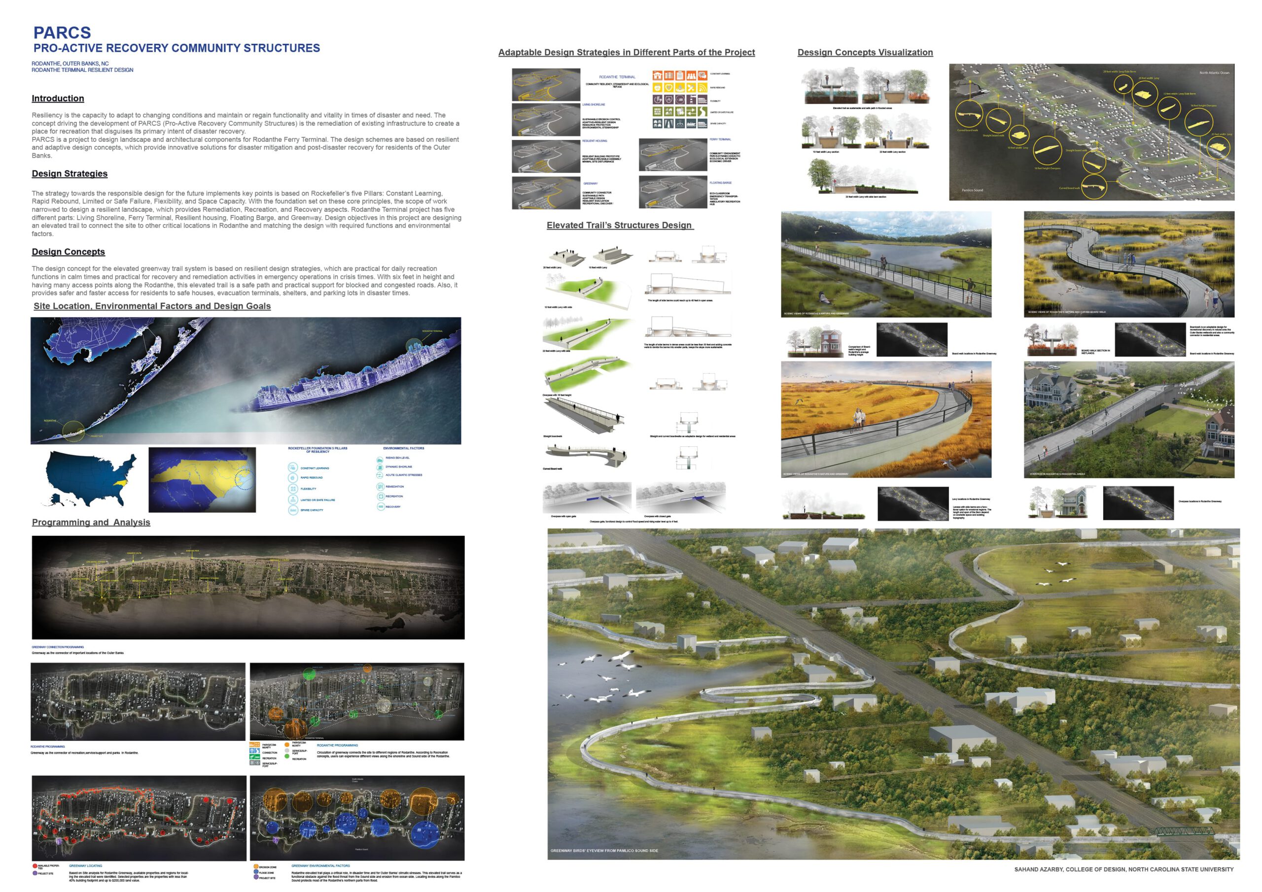
PARCS is a project to design landscape and architectural components for the Rodanthe Ferry terminal, Outer Banks, NC,USA.
The design method and strategies are based on resilient and adaptive design concepts with innovative solutions for disaster mitigation and post-disaster recovery of Outer Banks’ residents.
DLA | Digital Landscape Architecture


 Moderation