May 26 2021, DLA Workshop Day
Registration for DLA 2021 Conference will be available by April 1, 2021
You will receive the links to your virtual rooms after registration
Workshop 1: Geodesign
15:00 (Berlin) / 09 AM (New York) to 21:00 (Berlin) / 03 PM (New York): one day
with Prof. Dr. Carl Steinitz, Prof. Michele Campagna, and Dr. Hrishikesh Ballal of Geodesignhub software. No prior experience or special software required.
THE DLA 2021 GEODESIGN WORKSHOP
The DLA 2021 geodesign workshop will occur in one day, on May 26. It will be allremote and conducted on ZOOM. The focus of the workshop will be geodesign changesynthesis and its dynamic impacts and costs assessment. We will be considering many
of the sometimes conflicting ideas for the region of Cagliari, Sardinia, which have been proposed in past studies. We will undertake a simulated negotiation process to explore developing a consensus towards these alternative futures. We will be working within the structure of the International Geodesign Collaboration (IGC). See https://www.igcgeodesign.org/geodesign-workshops.
We will be using Geodesignhub (www.geodesignhub.com) for this workshop. The software has been built by Hrishi Ballal and has been used more than 100 times for early studies of areas undergoing contentious pressures for significant change. It is a
digital web based workflow based on a systems-approach. It is designed to among foster collaboration and negotiation among professionals and their clients, and among teams of professionals, especially during the early stages of design. It has a simple user interface which uses ubiquitous web technology and communication systems. It easily incorporates existing and diverse data structures for both its inputs and outputs, and it enables users to collaborate in person and/or over the internet in real time to produce designs and assess them. The participants in the workshop will be given training on the tool’s usage and there will be help and support available at hand in person and also in the form of articles and videos on software usage provided on the Geodesignhub.com web site and available to participants prior to the workshop.
Participation:
There will be a limit of 30 participants. For faculty, doctoral students and active professionals, Inclusion will be on a “first signed-first entered” basis. Students will be placed on a wait list based also on “first signed-first entered”. Final enrollments will be made a week before the workshop.
Date and Time:
The one day workshop will begin promptly at 9am EDT (New York) on Wednesday May 26. Please arrive at least 20 minutes before the start to get settled and to sign into Geodesignhub. We will end by 5pm. All are expected to participate full time.
Equipment:
You will need a recently made laptop computer. You will need a screen resolution of at least 1366×768. Most modern laptops built after 2012 should work, and the more modern the laptop the better. Please have Google Chrome or Mozilla Firefox installed
Workshop 2: UAV in Landscape Architecture
15:00 (Berlin) / 09 AM (New York) to 16:30 (Berlin) / 10:30 PM (New York): 90 minutes
Description:
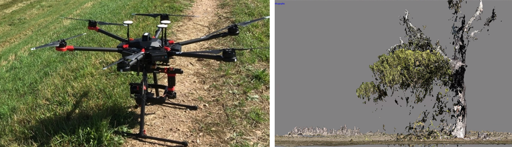
The use of UAV offers a wide range of possibilities that can be used in landscape architecture. Different sensor systems are available for this purpose. Aerial photography, the derivation of 3D point clouds, thermal or hyperspectral imaging offer a wide range of use cases. In the workshop, use cases as well as practical requirements will be presented and discussed.
The workshop will cover the following topics:
- Presentation of different UAV and sensor systems.
- Presentation of the working process for the generation of orthophotos and surface models.
- Resolution and accuracy requirements.
- Use cases in landscape architecture, landscape planning and nature conservation.
- Discussion of future requirements and possible applications.
- Discussion of integration opportunities in landscape architecture and environmental planning education programs.
Presenters:
- Jozef Sedlacek, PhD., AKM – landscape modeling lab, Department of Landscape Planning, Mendel University in Brno, Czech Republic
- Radim Klepárník, AKM – landscape modeling lab, Department of Landscape Planning, Mendel University in Brno, Czech Republic
- Matthias Pietsch, Prof. Dr., Landscape Architect, Head of Research Group Applied Geoinformatics and Remote Sensing, Anhalt University of Applied Sciences, Bernburg, Germany
- Dae Yong Kim, Research Group Applied Geoinformatics and Remote Sensing, Anhalt University of Applied Sciences, Bernburg.
Workshop 3: Applying BIM Workflows to Site Design and Documentation
with Prof. Eric Gilbey, PLA, ASLA, Member APLD, Product Marketing Manager – Landscape of Vectorworks, Inc.
Wednesday May 26, AUDITORIUM
Begin: 11:00 AM EDT (New York) / 17:00 CEST (Berlin)
Proposal Description:
Building design professionals are increasingly adopting Building Information Modeling (BIM) in their projects and asking Landscape Architects to use the same processes. This workshop will introduce site-specific BIM processes and describe how current technology supports Landscape Architecture curriculums in preparing professionals to use these workflows in their site design, analysis and documentation.
Learning Objectives/Outcomes:
Participants in this workshop will
1. Learn how imported files from allied professionals can be converted to information modeling objects, such as digital terrain models (DTM), from which design and analysis can proceed.
2. Discover how quickly parametric objects, like walls with constructed components, can be utilized to affect the other smart hybrid objects in proposed site development.
3. Realize efficiencies gained by using referenced viewport tools to develop enlarged plans and live section views, further linking documentation throughout the project.
See also:
DLA 2021 Workshop 6:
Learn BIM Projects with “BIM for Landscape” Template in Vectorworks Landmark (60 minutes) by ComputerWorks
Friday 28, 2021- ROOM 3
Begin: 10:00 AM EDT (New York) / 16:00 CEST (Berlin)
Proposal Description:
Building design professionals are increasingly adopting Building Information Modeling (BIM) in their projects and asking landscape architects to do the same. This workshop will guide you through several steps and questions most BIM projects will have, and also serve as an overview about the use of BIM workflows in a landscape BIM project.
Learning Objectives/Outcomes:
Participants in this workshop will
1. Learn how IFC elements can be grouped for cost calculation (e.g., cost group 500 of DIN 276).
2. See how to convert any object into an IFC object while adding data and preparing it for IFC export (e.g., export the LOD information from objects).
3. Discover examples of parametric marionette objects and the handling of the corresponding IFC data.
4. Learn the use of data visualization to check whether all relevant objects contain the necessary IFC information.
Workshop 4A + 4B: BIM Features and Landscape Modelling with Lands Design
Workshop 4A: BIM features and Landscape Modelling with Lands Design Software
17:00 (Berlin) / 11 AM (New York) to 18:30 (Berlin) / 12:30 PM (New York): 90
minutes Workshop 4B: BIM features and Landscape Modelling with Lands Design Software
Description:
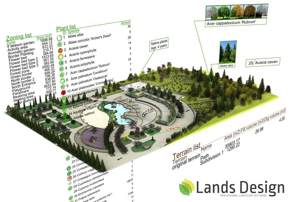
Lands Design is a landscape design software enhanced with BIM technology. It has 2 versions working as plugins for AutoCAD and for Rhino.
This workshop presents the main characteristics of Lands Design by developing a landscape design project, from drawing to 3D modelling.
The software key features will be addressed in this session. These include tools for terrain modelling, hardscape, vegetation, visualization and documentation.
Learning objectives:
1. Learn how to model a landscape with 3D modelling tools in Land Design, including how to create a terrain, insert vegetation, and apply hardscape tools.
2. View the project documentation process: generate drawings and lists of materials.
3. See how Grasshopper integration works: how to automate a parametric design process with Grasshopper's Lands Design components.
4. Get a preview of the visualization tools: animations, rendering options and virtual tours.
Lands Design website: http://www.landsdesign.com/
Instructors:
• Elham Ghabouli, Ph.D. in Urban and Architectural management, Landscape Architect. Product Manager at Asuni.
• Francesc Salla, Architect and BIM specialist, Product Manager of VisualARQ and Lands Design at Asuni.
Further descriptions and further workshop offers are following
May 28 2021, Friday
Workshop 6: Applying BIM Workflows to Site Design and Documentation
With Oliver Sachs, CAD und BIM-Technology Lecturer at the Department of Architecture at HTW University Saar
and with Eric Gilbey, PLA, ASLA, Member APLD, Product Marketing Manager – Landscape of Vectorworks, Inc.
Friday May 28, ROOM 3
Begin: 10:00 AM EDT (New York) / 16:00 CEST (Berlin)
Title: Learn BIM Projects with “BIM for Landscape” Template in Vectorworks Landmark
Proposal Description:
Building design professionals are increasingly adopting Building Information Modeling (BIM) in their projects and asking landscape architects to do the same. This workshop will guide you through several steps and questions most BIM projects will have, and also serve as an overview about the use of BIM workflows in a landscape BIM project.
Learning Objectives/Outcomes:
Participants in this workshop will
1. Learn how IFC elements can be grouped for cost calculation (e.g., cost group 500 of DIN 276)
2. See how to convert any object into an IFC object while adding data and preparing it for IFC export (e.g., export the LOD information from objects).
3. Discover examples of parametric marionette objects and the handling of the corresponding IFC data.
4. Learn the use of data visualization to check whether all relevant objects contain the necessary IFC information.
Further descriptions and further workshop offers are following
DLA | Digital Landscape Architecture


 Moderation